You are here: Home > Network List > US - United States National Seismic Network Stations List
> Station LAO LASA Array, Montana, USA > Earthquake Result Viewer
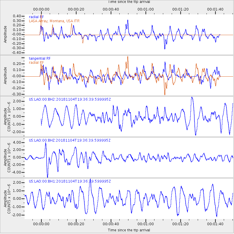
LAO LASA Array, Montana, USA - Earthquake Result Viewer
*The percent match for this event was below the threshold and hence no stack was calculated.
| Earthquake location: |
Hokkaido, Japan Region |
| Earthquake latitude/longitude: |
44.6/145.6 |
| Earthquake time(UTC): |
2018/11/04 (308) 19:26:03 GMT |
| Earthquake Depth: |
8.0 km |
| Earthquake Magnitude: |
5.9 Mww |
| Earthquake Catalog/Contributor: |
NEIC PDE/us |
|
| Network: |
US United States National Seismic Network |
| Station: |
LAO LASA Array, Montana, USA |
| Lat/Lon: |
46.69 N/106.22 W |
| Elevation: |
902 m |
|
| Distance: |
69.3 deg |
| Az: |
44.364 deg |
| Baz: |
313.444 deg |
| Ray Param: |
$rayparam |
*The percent match for this event was below the threshold and hence was not used in the summary stack. |
|
| Radial Match: |
66.5691 % |
| Radial Bump: |
400 |
| Transverse Match: |
70.625755 % |
| Transverse Bump: |
368 |
| SOD ConfigId: |
3131071 |
| Insert Time: |
2018-11-18 19:38:36.034 +0000 |
| GWidth: |
2.5 |
| Max Bumps: |
400 |
| Tol: |
0.001 |
|
Signal To Noise
| Channel | StoN | STA | LTA |
| US:LAO:00:BHZ:20181104T19:36:39.599995Z | 9.355781 | 2.139582E-6 | 2.2869091E-7 |
| US:LAO:00:BH1:20181104T19:36:39.599995Z | 2.0381868 | 7.8966855E-7 | 3.8743678E-7 |
| US:LAO:00:BH2:20181104T19:36:39.599995Z | 0.37442487 | 3.3591596E-7 | 8.971519E-7 |
| Arrivals |
| Ps | |
| PpPs | |
| PsPs/PpSs | |


