You are here: Home > Network List > OK - Oklahoma Seismic Network Stations List
> Station DEOK Depew, Oklahoma, USA > Earthquake Result Viewer
DEOK Depew, Oklahoma, USA - Earthquake Result Viewer
| Earthquake location: |
South Of Fiji Islands |
| Earthquake latitude/longitude: |
-23.0/-177.2 |
| Earthquake time(UTC): |
2023/06/15 (166) 18:06:27 GMT |
| Earthquake Depth: |
167 km |
| Earthquake Magnitude: |
7.2 Mww |
| Earthquake Catalog/Contributor: |
NEIC PDE/us |
|
| Network: |
OK Oklahoma Seismic Network |
| Station: |
DEOK Depew, Oklahoma, USA |
| Lat/Lon: |
35.84 N/96.50 W |
| Elevation: |
291 m |
|
| Distance: |
96.1 deg |
| Az: |
53.738 deg |
| Baz: |
246.145 deg |
| Ray Param: |
0.040487472 |
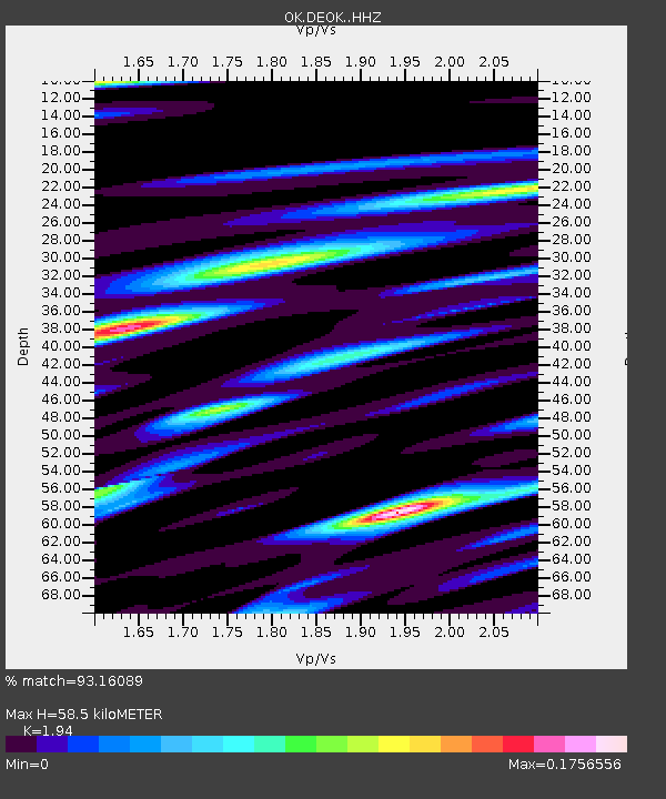
| Estimated Moho Depth: |
58.5 km |
| Estimated Crust Vp/Vs: |
1.94 |
| Assumed Crust Vp: |
6.426 km/s |
| Estimated Crust Vs: |
3.312 km/s |
| Estimated Crust Poisson's Ratio: |
0.32 |
|
| Radial Match: |
93.16089 % |
| Radial Bump: |
383 |
| Transverse Match: |
92.385284 % |
| Transverse Bump: |
400 |
| SOD ConfigId: |
30536071 |
| Insert Time: |
2023-06-29 18:59:56.774 +0000 |
| GWidth: |
2.5 |
| Max Bumps: |
400 |
| Tol: |
0.001 |
|

Signal To Noise
| Channel | StoN | STA | LTA |
| OK:DEOK: :HHZ:20230615T18:19:04.650009Z | 17.25435 | 6.668773E-7 | 3.864981E-8 |
| OK:DEOK: :HHN:20230615T18:19:04.650009Z | 1.5148731 | 2.637903E-9 | 1.7413357E-9 |
| OK:DEOK: :HHE:20230615T18:19:04.650009Z | 3.8793318 | 6.4207526E-8 | 1.6551182E-8 |
| Arrivals |
| Ps | 8.7 SECOND |
| PpPs | 26 SECOND |
| PsPs/PpSs | 35 SECOND |


