You are here: Home > Network List > OK - Oklahoma Seismic Network Stations List
> Station FNO Franklin, Norman, OK > Earthquake Result Viewer
FNO Franklin, Norman, OK - Earthquake Result Viewer
| Earthquake location: |
South Of Fiji Islands |
| Earthquake latitude/longitude: |
-23.0/-177.2 |
| Earthquake time(UTC): |
2023/06/15 (166) 18:06:27 GMT |
| Earthquake Depth: |
167 km |
| Earthquake Magnitude: |
7.2 Mww |
| Earthquake Catalog/Contributor: |
NEIC PDE/us |
|
| Network: |
OK Oklahoma Seismic Network |
| Station: |
FNO Franklin, Norman, OK |
| Lat/Lon: |
35.26 N/97.40 W |
| Elevation: |
360 m |
|
| Distance: |
95.1 deg |
| Az: |
53.972 deg |
| Baz: |
245.6 deg |
| Ray Param: |
0.04074167 |
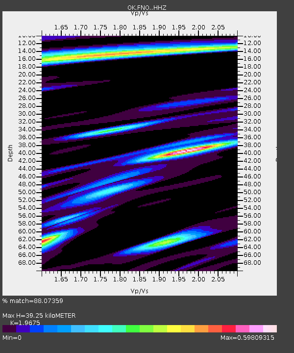
| Estimated Moho Depth: |
39.25 km |
| Estimated Crust Vp/Vs: |
1.97 |
| Assumed Crust Vp: |
6.426 km/s |
| Estimated Crust Vs: |
3.266 km/s |
| Estimated Crust Poisson's Ratio: |
0.33 |
|
| Radial Match: |
88.07359 % |
| Radial Bump: |
400 |
| Transverse Match: |
87.666374 % |
| Transverse Bump: |
400 |
| SOD ConfigId: |
30536071 |
| Insert Time: |
2023-06-29 18:59:59.285 +0000 |
| GWidth: |
2.5 |
| Max Bumps: |
400 |
| Tol: |
0.001 |
|

Signal To Noise
| Channel | StoN | STA | LTA |
| OK:FNO: :HHZ:20230615T18:19:00.554977Z | 16.432953 | 2.0019388E-6 | 1.2182466E-7 |
| OK:FNO: :HHN:20230615T18:19:00.554977Z | 1.5747726 | 6.952431E-9 | 4.4148796E-9 |
| OK:FNO: :HHE:20230615T18:19:00.554977Z | 3.0442376 | 4.9279146E-7 | 1.6187681E-7 |
| Arrivals |
| Ps | 6.0 SECOND |
| PpPs | 18 SECOND |
| PsPs/PpSs | 24 SECOND |


