You are here: Home > Network List > PQ - Public Safety Geoscience Program Canadian Research Network (PSGP) Stations List
> Station ALBHB Albert Head, Victoria, BC, Canada > Earthquake Result Viewer
ALBHB Albert Head, Victoria, BC, Canada - Earthquake Result Viewer
| Earthquake location: |
South Of Fiji Islands |
| Earthquake latitude/longitude: |
-23.0/-177.2 |
| Earthquake time(UTC): |
2023/06/15 (166) 18:06:27 GMT |
| Earthquake Depth: |
167 km |
| Earthquake Magnitude: |
7.2 Mww |
| Earthquake Catalog/Contributor: |
NEIC PDE/us |
|
| Network: |
PQ Public Safety Geoscience Program Canadian Research Network (PSGP) |
| Station: |
ALBHB Albert Head, Victoria, BC, Canada |
| Lat/Lon: |
48.39 N/123.49 W |
| Elevation: |
40 m |
|
| Distance: |
85.8 deg |
| Az: |
32.603 deg |
| Baz: |
228.155 deg |
| Ray Param: |
0.04416273 |
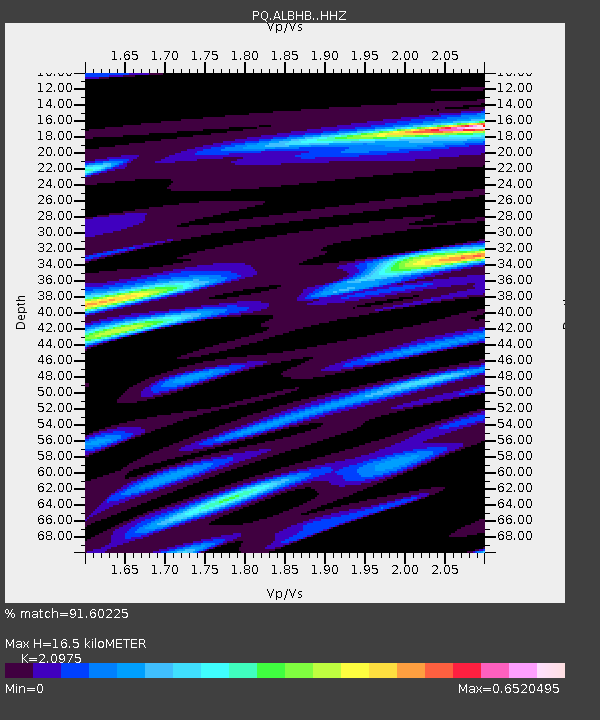
| Estimated Moho Depth: |
16.5 km |
| Estimated Crust Vp/Vs: |
2.10 |
| Assumed Crust Vp: |
6.566 km/s |
| Estimated Crust Vs: |
3.13 km/s |
| Estimated Crust Poisson's Ratio: |
0.35 |
|
| Radial Match: |
91.60225 % |
| Radial Bump: |
400 |
| Transverse Match: |
88.27375 % |
| Transverse Bump: |
400 |
| SOD ConfigId: |
30536071 |
| Insert Time: |
2023-06-29 19:00:56.917 +0000 |
| GWidth: |
2.5 |
| Max Bumps: |
400 |
| Tol: |
0.001 |
|

Signal To Noise
| Channel | StoN | STA | LTA |
| PQ:ALBHB: :HHZ:20230615T18:18:16.850021Z | 36.678257 | 4.409124E-6 | 1.2021084E-7 |
| PQ:ALBHB: :HHN:20230615T18:18:16.850021Z | 5.994257 | 9.551276E-7 | 1.5934043E-7 |
| PQ:ALBHB: :HHE:20230615T18:18:16.850021Z | 9.28963 | 9.271152E-7 | 9.980109E-8 |
| Arrivals |
| Ps | 2.8 SECOND |
| PpPs | 7.6 SECOND |
| PsPs/PpSs | 10 SECOND |


