You are here: Home > Network List > TA - USArray Transportable Network (new EarthScope stations) Stations List
> Station M04C Macdoel, CA, USA > Earthquake Result Viewer
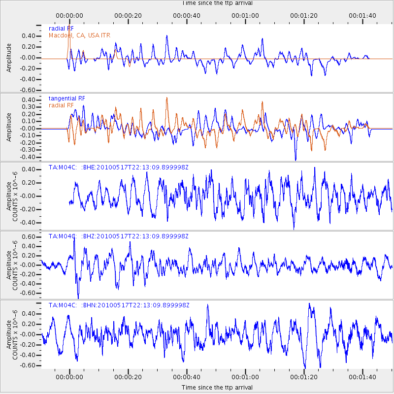
M04C Macdoel, CA, USA - Earthquake Result Viewer
*The percent match for this event was below the threshold and hence no stack was calculated.
| Earthquake location: |
Kuril Islands |
| Earthquake latitude/longitude: |
46.3/152.0 |
| Earthquake time(UTC): |
2010/05/17 (137) 22:03:47 GMT |
| Earthquake Depth: |
73 km |
| Earthquake Magnitude: |
5.7 MB, 5.3 MW |
| Earthquake Catalog/Contributor: |
WHDF/NEIC |
|
| Network: |
TA USArray Transportable Network (new EarthScope stations) |
| Station: |
M04C Macdoel, CA, USA |
| Lat/Lon: |
41.78 N/121.84 W |
| Elevation: |
1391 m |
|
| Distance: |
59.1 deg |
| Az: |
60.389 deg |
| Baz: |
306.285 deg |
| Ray Param: |
$rayparam |
*The percent match for this event was below the threshold and hence was not used in the summary stack. |
|
| Radial Match: |
49.595825 % |
| Radial Bump: |
400 |
| Transverse Match: |
56.32116 % |
| Transverse Bump: |
400 |
| SOD ConfigId: |
314592 |
| Insert Time: |
2010-09-04 06:46:28.114 +0000 |
| GWidth: |
2.5 |
| Max Bumps: |
400 |
| Tol: |
0.001 |
|
Signal To Noise
| Channel | StoN | STA | LTA |
| TA:M04C: :BHZ:20100517T22:13:09.899998Z | 3.8719962 | 2.955841E-7 | 7.633895E-8 |
| TA:M04C: :BHN:20100517T22:13:09.899998Z | 2.0025291 | 2.5013784E-7 | 1.2491095E-7 |
| TA:M04C: :BHE:20100517T22:13:09.899998Z | 1.4014813 | 1.831147E-7 | 1.3065798E-7 |
| Arrivals |
| Ps | |
| PpPs | |
| PsPs/PpSs | |


