You are here: Home > Network List > SC - New Mexico Tech Seismic Network Stations List
> Station GDL2 Guadalupe Mountains, New Mexico > Earthquake Result Viewer
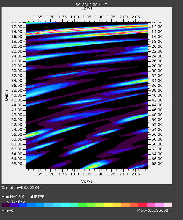
GDL2 Guadalupe Mountains, New Mexico - Earthquake Result Viewer
| Earthquake location: |
South Of Fiji Islands |
| Earthquake latitude/longitude: |
-23.0/-177.2 |
| Earthquake time(UTC): |
2023/06/15 (166) 18:06:27 GMT |
| Earthquake Depth: |
167 km |
| Earthquake Magnitude: |
7.2 Mww |
| Earthquake Catalog/Contributor: |
NEIC PDE/us |
|
| Network: |
SC New Mexico Tech Seismic Network |
| Station: |
GDL2 Guadalupe Mountains, New Mexico |
| Lat/Lon: |
32.20 N/104.36 W |
| Elevation: |
1211 m |
|
| Distance: |
88.6 deg |
| Az: |
54.127 deg |
| Baz: |
241.742 deg |
| Ray Param: |
0.04210392 |
| Estimated Moho Depth: |
13.0 km |
| Estimated Crust Vp/Vs: |
1.80 |
| Assumed Crust Vp: |
6.232 km/s |
| Estimated Crust Vs: |
3.467 km/s |
| Estimated Crust Poisson's Ratio: |
0.28 |
|
| Radial Match: |
93.602844 % |
| Radial Bump: |
400 |
| Transverse Match: |
89.804855 % |
| Transverse Bump: |
400 |
| SOD ConfigId: |
30536071 |
| Insert Time: |
2023-06-29 19:03:43.587 +0000 |
| GWidth: |
2.5 |
| Max Bumps: |
400 |
| Tol: |
0.001 |
|

Signal To Noise
| Channel | StoN | STA | LTA |
| SC:GDL2:00:HHZ:20230615T18:18:30.455001Z | 98.38308 | 5.283609E-7 | 5.370445E-9 |
| SC:GDL2:00:HHN:20230615T18:18:30.455001Z | 12.324031 | 5.460456E-8 | 4.4307384E-9 |
| SC:GDL2:00:HHE:20230615T18:18:30.455001Z | 21.134531 | 5.998045E-8 | 2.838031E-9 |
| Arrivals |
| Ps | 1.7 SECOND |
| PpPs | 5.7 SECOND |
| PsPs/PpSs | 7.4 SECOND |


