You are here: Home > Network List > TA - USArray Transportable Network (new EarthScope stations) Stations List
> Station N23A Red Feather Lakes, CO, USA > Earthquake Result Viewer
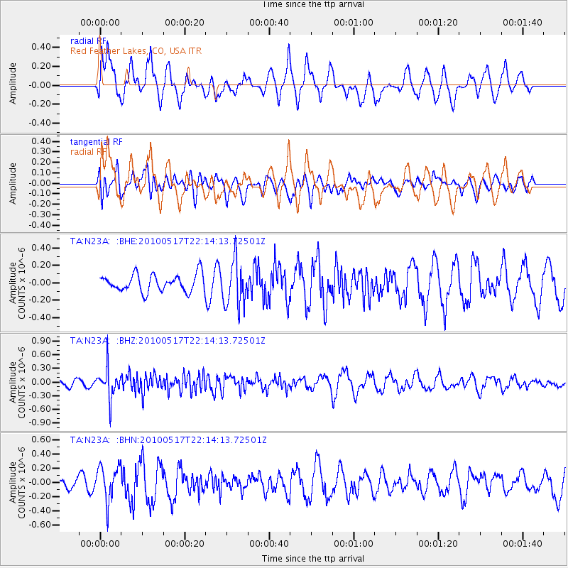
N23A Red Feather Lakes, CO, USA - Earthquake Result Viewer
*The percent match for this event was below the threshold and hence no stack was calculated.
| Earthquake location: |
Kuril Islands |
| Earthquake latitude/longitude: |
46.3/152.0 |
| Earthquake time(UTC): |
2010/05/17 (137) 22:03:47 GMT |
| Earthquake Depth: |
73 km |
| Earthquake Magnitude: |
5.7 MB, 5.3 MW |
| Earthquake Catalog/Contributor: |
WHDF/NEIC |
|
| Network: |
TA USArray Transportable Network (new EarthScope stations) |
| Station: |
N23A Red Feather Lakes, CO, USA |
| Lat/Lon: |
40.89 N/105.94 W |
| Elevation: |
2458 m |
|
| Distance: |
68.9 deg |
| Az: |
52.633 deg |
| Baz: |
313.366 deg |
| Ray Param: |
$rayparam |
*The percent match for this event was below the threshold and hence was not used in the summary stack. |
|
| Radial Match: |
60.32071 % |
| Radial Bump: |
400 |
| Transverse Match: |
59.36875 % |
| Transverse Bump: |
400 |
| SOD ConfigId: |
314592 |
| Insert Time: |
2010-09-04 06:48:09.670 +0000 |
| GWidth: |
2.5 |
| Max Bumps: |
400 |
| Tol: |
0.001 |
|
Signal To Noise
| Channel | StoN | STA | LTA |
| TA:N23A: :BHZ:20100517T22:14:13.72501Z | 3.4418013 | 3.2460457E-7 | 9.4312405E-8 |
| TA:N23A: :BHN:20100517T22:14:13.72501Z | 2.537066 | 2.464395E-7 | 9.7135626E-8 |
| TA:N23A: :BHE:20100517T22:14:13.72501Z | 2.6613436 | 2.6160865E-7 | 9.8299466E-8 |
| Arrivals |
| Ps | |
| PpPs | |
| PsPs/PpSs | |


