You are here: Home > Network List > TX - Texas Seismological Network Stations List
> Station ET01 Chireno > Earthquake Result Viewer
ET01 Chireno - Earthquake Result Viewer
| Earthquake location: |
South Of Fiji Islands |
| Earthquake latitude/longitude: |
-23.0/-177.2 |
| Earthquake time(UTC): |
2023/06/15 (166) 18:06:27 GMT |
| Earthquake Depth: |
167 km |
| Earthquake Magnitude: |
7.2 Mww |
| Earthquake Catalog/Contributor: |
NEIC PDE/us |
|
| Network: |
TX Texas Seismological Network |
| Station: |
ET01 Chireno |
| Lat/Lon: |
31.46 N/94.37 W |
| Elevation: |
127 m |
|
| Distance: |
95.9 deg |
| Az: |
58.478 deg |
| Baz: |
246.827 deg |
| Ray Param: |
0.04051912 |
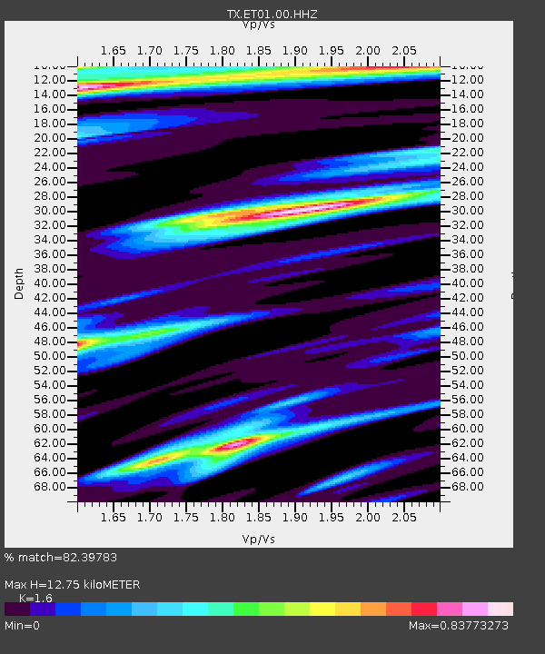
| Estimated Moho Depth: |
12.75 km |
| Estimated Crust Vp/Vs: |
1.60 |
| Assumed Crust Vp: |
5.738 km/s |
| Estimated Crust Vs: |
3.587 km/s |
| Estimated Crust Poisson's Ratio: |
0.18 |
|
| Radial Match: |
82.39783 % |
| Radial Bump: |
400 |
| Transverse Match: |
68.83544 % |
| Transverse Bump: |
400 |
| SOD ConfigId: |
30536071 |
| Insert Time: |
2023-06-29 19:05:26.325 +0000 |
| GWidth: |
2.5 |
| Max Bumps: |
400 |
| Tol: |
0.001 |
|

Signal To Noise
| Channel | StoN | STA | LTA |
| TX:ET01:00:HHZ:20230615T18:19:04.160019Z | 8.39588 | 1.9962E-6 | 2.3775945E-7 |
| TX:ET01:00:HH1:20230615T18:19:04.160019Z | 1.6719332 | 6.3626874E-7 | 3.8055873E-7 |
| TX:ET01:00:HH2:20230615T18:19:04.160019Z | 1.1915923 | 5.21258E-7 | 4.3744663E-7 |
| Arrivals |
| Ps | 1.4 SECOND |
| PpPs | 5.7 SECOND |
| PsPs/PpSs | 7.0 SECOND |


