You are here: Home > Network List > TA - USArray Transportable Network (new EarthScope stations) Stations List
> Station G21A Lodge Grass, MT, USA > Earthquake Result Viewer
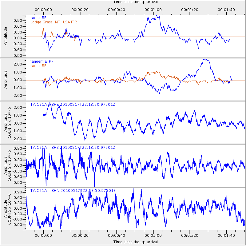
G21A Lodge Grass, MT, USA - Earthquake Result Viewer
*The percent match for this event was below the threshold and hence no stack was calculated.
| Earthquake location: |
Kuril Islands |
| Earthquake latitude/longitude: |
46.3/152.0 |
| Earthquake time(UTC): |
2010/05/17 (137) 22:03:47 GMT |
| Earthquake Depth: |
73 km |
| Earthquake Magnitude: |
5.7 MB, 5.3 MW |
| Earthquake Catalog/Contributor: |
WHDF/NEIC |
|
| Network: |
TA USArray Transportable Network (new EarthScope stations) |
| Station: |
G21A Lodge Grass, MT, USA |
| Lat/Lon: |
45.22 N/107.21 W |
| Elevation: |
1227 m |
|
| Distance: |
65.3 deg |
| Az: |
49.841 deg |
| Baz: |
311.418 deg |
| Ray Param: |
$rayparam |
*The percent match for this event was below the threshold and hence was not used in the summary stack. |
|
| Radial Match: |
29.077349 % |
| Radial Bump: |
400 |
| Transverse Match: |
34.695698 % |
| Transverse Bump: |
400 |
| SOD ConfigId: |
314592 |
| Insert Time: |
2010-09-04 06:48:38.657 +0000 |
| GWidth: |
2.5 |
| Max Bumps: |
400 |
| Tol: |
0.001 |
|
Signal To Noise
| Channel | StoN | STA | LTA |
| TA:G21A: :BHZ:20100517T22:13:50.97501Z | 2.0995598 | 4.648431E-7 | 2.2140027E-7 |
| TA:G21A: :BHN:20100517T22:13:50.97501Z | 1.1703796 | 6.1633915E-7 | 5.266147E-7 |
| TA:G21A: :BHE:20100517T22:13:50.97501Z | 0.8734422 | 1.0471059E-6 | 1.1988268E-6 |
| Arrivals |
| Ps | |
| PpPs | |
| PsPs/PpSs | |


