You are here: Home > Network List > TX - Texas Seismological Network Stations List
> Station PB10 Southeast of Toyah > Earthquake Result Viewer
PB10 Southeast of Toyah - Earthquake Result Viewer
| Earthquake location: |
South Of Fiji Islands |
| Earthquake latitude/longitude: |
-23.0/-177.2 |
| Earthquake time(UTC): |
2023/06/15 (166) 18:06:27 GMT |
| Earthquake Depth: |
167 km |
| Earthquake Magnitude: |
7.2 Mww |
| Earthquake Catalog/Contributor: |
NEIC PDE/us |
|
| Network: |
TX Texas Seismological Network |
| Station: |
PB10 Southeast of Toyah |
| Lat/Lon: |
31.28 N/103.75 W |
| Elevation: |
858 m |
|
| Distance: |
88.6 deg |
| Az: |
55.178 deg |
| Baz: |
242.086 deg |
| Ray Param: |
0.042084128 |
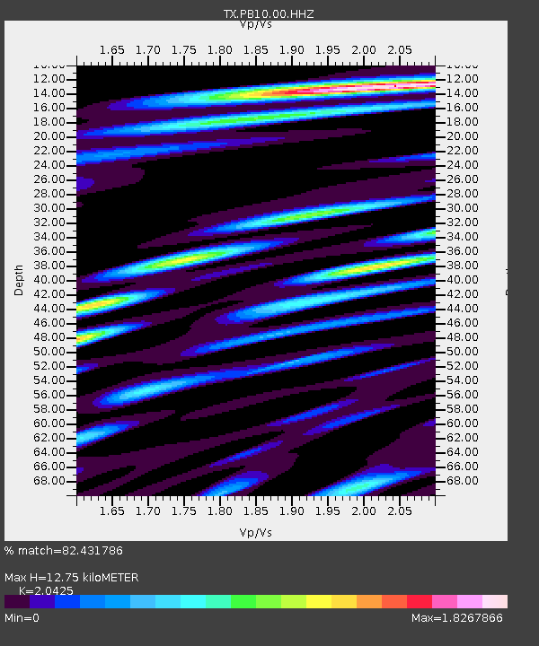
| Estimated Moho Depth: |
12.75 km |
| Estimated Crust Vp/Vs: |
2.04 |
| Assumed Crust Vp: |
6.121 km/s |
| Estimated Crust Vs: |
2.997 km/s |
| Estimated Crust Poisson's Ratio: |
0.34 |
|
| Radial Match: |
82.431786 % |
| Radial Bump: |
400 |
| Transverse Match: |
65.97591 % |
| Transverse Bump: |
400 |
| SOD ConfigId: |
30536071 |
| Insert Time: |
2023-06-29 19:06:02.757 +0000 |
| GWidth: |
2.5 |
| Max Bumps: |
400 |
| Tol: |
0.001 |
|

Signal To Noise
| Channel | StoN | STA | LTA |
| TX:PB10:00:HHZ:20230615T18:18:30.580001Z | 7.862819 | 1.9002788E-6 | 2.4167906E-7 |
| TX:PB10:00:HH1:20230615T18:18:30.580001Z | 3.2315774 | 5.9205377E-7 | 1.8320891E-7 |
| TX:PB10:00:HH2:20230615T18:18:30.580001Z | 4.829613 | 9.604694E-7 | 1.9887086E-7 |
| Arrivals |
| Ps | 2.2 SECOND |
| PpPs | 6.2 SECOND |
| PsPs/PpSs | 8.4 SECOND |


