You are here: Home > Network List > UO - University of Oregon Regional Network Stations List
> Station GROV Forest Grove, OR, USA > Earthquake Result Viewer
GROV Forest Grove, OR, USA - Earthquake Result Viewer
| Earthquake location: |
South Of Fiji Islands |
| Earthquake latitude/longitude: |
-23.0/-177.2 |
| Earthquake time(UTC): |
2023/06/15 (166) 18:06:27 GMT |
| Earthquake Depth: |
167 km |
| Earthquake Magnitude: |
7.2 Mww |
| Earthquake Catalog/Contributor: |
NEIC PDE/us |
|
| Network: |
UO University of Oregon Regional Network |
| Station: |
GROV Forest Grove, OR, USA |
| Lat/Lon: |
45.54 N/123.16 W |
| Elevation: |
99 m |
|
| Distance: |
84.0 deg |
| Az: |
34.895 deg |
| Baz: |
228.6 deg |
| Ray Param: |
0.04538786 |
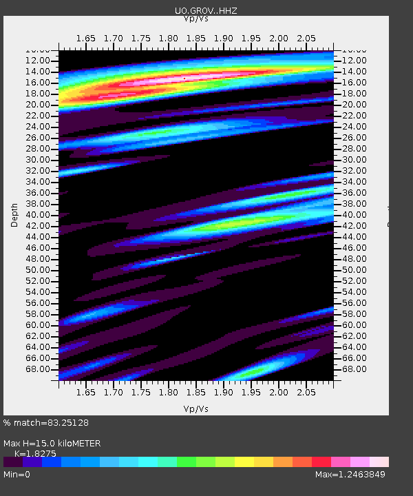
| Estimated Moho Depth: |
15.0 km |
| Estimated Crust Vp/Vs: |
1.83 |
| Assumed Crust Vp: |
6.566 km/s |
| Estimated Crust Vs: |
3.593 km/s |
| Estimated Crust Poisson's Ratio: |
0.29 |
|
| Radial Match: |
83.25128 % |
| Radial Bump: |
400 |
| Transverse Match: |
79.00335 % |
| Transverse Bump: |
400 |
| SOD ConfigId: |
30536071 |
| Insert Time: |
2023-06-29 19:07:14.807 +0000 |
| GWidth: |
2.5 |
| Max Bumps: |
400 |
| Tol: |
0.001 |
|

Signal To Noise
| Channel | StoN | STA | LTA |
| UO:GROV: :HHZ:20230615T18:18:08.280014Z | 8.608185 | 5.4683096E-6 | 6.352453E-7 |
| UO:GROV: :HHN:20230615T18:18:08.280014Z | 1.8591672 | 1.1279095E-6 | 6.0667463E-7 |
| UO:GROV: :HHE:20230615T18:18:08.280014Z | 2.3668408 | 1.8373322E-6 | 7.762804E-7 |
| Arrivals |
| Ps | 1.9 SECOND |
| PpPs | 6.3 SECOND |
| PsPs/PpSs | 8.2 SECOND |


