You are here: Home > Network List > UO - University of Oregon Regional Network Stations List
> Station MINN McMinnville, OR, USA > Earthquake Result Viewer
MINN McMinnville, OR, USA - Earthquake Result Viewer
| Earthquake location: |
South Of Fiji Islands |
| Earthquake latitude/longitude: |
-23.0/-177.2 |
| Earthquake time(UTC): |
2023/06/15 (166) 18:06:27 GMT |
| Earthquake Depth: |
167 km |
| Earthquake Magnitude: |
7.2 Mww |
| Earthquake Catalog/Contributor: |
NEIC PDE/us |
|
| Network: |
UO University of Oregon Regional Network |
| Station: |
MINN McMinnville, OR, USA |
| Lat/Lon: |
45.21 N/123.26 W |
| Elevation: |
222 m |
|
| Distance: |
83.8 deg |
| Az: |
35.091 deg |
| Baz: |
228.545 deg |
| Ray Param: |
0.045576334 |
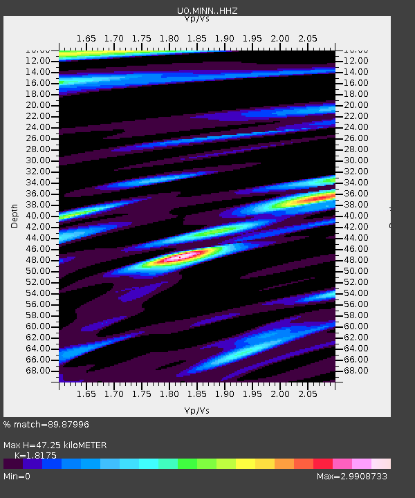
| Estimated Moho Depth: |
47.25 km |
| Estimated Crust Vp/Vs: |
1.82 |
| Assumed Crust Vp: |
6.566 km/s |
| Estimated Crust Vs: |
3.613 km/s |
| Estimated Crust Poisson's Ratio: |
0.28 |
|
| Radial Match: |
89.87996 % |
| Radial Bump: |
400 |
| Transverse Match: |
83.4197 % |
| Transverse Bump: |
400 |
| SOD ConfigId: |
30536071 |
| Insert Time: |
2023-06-29 19:07:38.767 +0000 |
| GWidth: |
2.5 |
| Max Bumps: |
400 |
| Tol: |
0.001 |
|

Signal To Noise
| Channel | StoN | STA | LTA |
| UO:MINN: :HHZ:20230615T18:18:06.897995Z | 10.699574 | 3.0212627E-6 | 2.8237224E-7 |
| UO:MINN: :HHN:20230615T18:18:06.897995Z | 4.056641 | 1.4064725E-6 | 3.4670865E-7 |
| UO:MINN: :HHE:20230615T18:18:06.897995Z | 2.4185472 | 1.5254484E-6 | 6.307293E-7 |
| Arrivals |
| Ps | 6.0 SECOND |
| PpPs | 20 SECOND |
| PsPs/PpSs | 26 SECOND |


