You are here: Home > Network List > UO - University of Oregon Regional Network Stations List
> Station NECAN Necanicum, OR, USA > Earthquake Result Viewer
NECAN Necanicum, OR, USA - Earthquake Result Viewer
| Earthquake location: |
South Of Fiji Islands |
| Earthquake latitude/longitude: |
-23.0/-177.2 |
| Earthquake time(UTC): |
2023/06/15 (166) 18:06:27 GMT |
| Earthquake Depth: |
167 km |
| Earthquake Magnitude: |
7.2 Mww |
| Earthquake Catalog/Contributor: |
NEIC PDE/us |
|
| Network: |
UO University of Oregon Regional Network |
| Station: |
NECAN Necanicum, OR, USA |
| Lat/Lon: |
45.87 N/123.82 W |
| Elevation: |
517 m |
|
| Distance: |
83.9 deg |
| Az: |
34.336 deg |
| Baz: |
228.065 deg |
| Ray Param: |
0.04547972 |
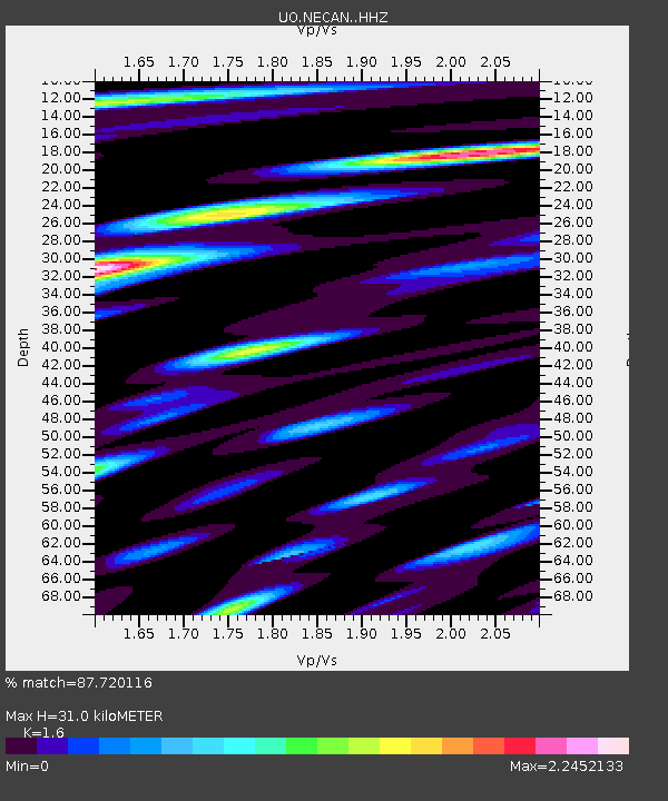
| Estimated Moho Depth: |
31.0 km |
| Estimated Crust Vp/Vs: |
1.60 |
| Assumed Crust Vp: |
6.566 km/s |
| Estimated Crust Vs: |
4.104 km/s |
| Estimated Crust Poisson's Ratio: |
0.18 |
|
| Radial Match: |
87.720116 % |
| Radial Bump: |
400 |
| Transverse Match: |
89.38043 % |
| Transverse Bump: |
400 |
| SOD ConfigId: |
30536071 |
| Insert Time: |
2023-06-29 19:07:45.311 +0000 |
| GWidth: |
2.5 |
| Max Bumps: |
400 |
| Tol: |
0.001 |
|

Signal To Noise
| Channel | StoN | STA | LTA |
| UO:NECAN: :HHZ:20230615T18:18:07.60997Z | 9.414895 | 7.993081E-6 | 8.489825E-7 |
| UO:NECAN: :HHN:20230615T18:18:07.60997Z | 3.5446103 | 2.3974192E-6 | 6.763562E-7 |
| UO:NECAN: :HHE:20230615T18:18:07.60997Z | 1.8013183 | 1.8911536E-6 | 1.0498719E-6 |
| Arrivals |
| Ps | 2.9 SECOND |
| PpPs | 12 SECOND |
| PsPs/PpSs | 15 SECOND |


