You are here: Home > Network List > UO - University of Oregon Regional Network Stations List
> Station RSBO Finn Rock, OR, USA > Earthquake Result Viewer
RSBO Finn Rock, OR, USA - Earthquake Result Viewer
| Earthquake location: |
South Of Fiji Islands |
| Earthquake latitude/longitude: |
-23.0/-177.2 |
| Earthquake time(UTC): |
2023/06/15 (166) 18:06:27 GMT |
| Earthquake Depth: |
167 km |
| Earthquake Magnitude: |
7.2 Mww |
| Earthquake Catalog/Contributor: |
NEIC PDE/us |
|
| Network: |
UO University of Oregon Regional Network |
| Station: |
RSBO Finn Rock, OR, USA |
| Lat/Lon: |
44.04 N/122.27 W |
| Elevation: |
1235 m |
|
| Distance: |
83.5 deg |
| Az: |
36.448 deg |
| Baz: |
229.393 deg |
| Ray Param: |
0.045734648 |
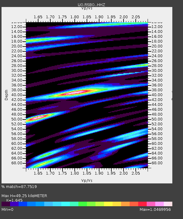
| Estimated Moho Depth: |
49.25 km |
| Estimated Crust Vp/Vs: |
1.64 |
| Assumed Crust Vp: |
6.566 km/s |
| Estimated Crust Vs: |
3.992 km/s |
| Estimated Crust Poisson's Ratio: |
0.21 |
|
| Radial Match: |
87.7519 % |
| Radial Bump: |
400 |
| Transverse Match: |
85.477554 % |
| Transverse Bump: |
400 |
| SOD ConfigId: |
30536071 |
| Insert Time: |
2023-06-29 19:08:01.765 +0000 |
| GWidth: |
2.5 |
| Max Bumps: |
400 |
| Tol: |
0.001 |
|

Signal To Noise
| Channel | StoN | STA | LTA |
| UO:RSBO: :HHZ:20230615T18:18:05.739975Z | 14.403915 | 4.1802673E-6 | 2.9021743E-7 |
| UO:RSBO: :HHN:20230615T18:18:05.739975Z | 2.904788 | 7.233751E-7 | 2.4902852E-7 |
| UO:RSBO: :HHE:20230615T18:18:05.739975Z | 2.4787364 | 1.0193467E-6 | 4.112364E-7 |
| Arrivals |
| Ps | 5.0 SECOND |
| PpPs | 19 SECOND |
| PsPs/PpSs | 24 SECOND |


