You are here: Home > Network List > US - United States National Seismic Network Stations List
> Station BW06 Boulder Array Site 6 (Pinedale), Wyoming, USA > Earthquake Result Viewer
BW06 Boulder Array Site 6 (Pinedale), Wyoming, USA - Earthquake Result Viewer
| Earthquake location: |
South Of Fiji Islands |
| Earthquake latitude/longitude: |
-23.0/-177.2 |
| Earthquake time(UTC): |
2023/06/15 (166) 18:06:27 GMT |
| Earthquake Depth: |
167 km |
| Earthquake Magnitude: |
7.2 Mww |
| Earthquake Catalog/Contributor: |
NEIC PDE/us |
|
| Network: |
US United States National Seismic Network |
| Station: |
BW06 Boulder Array Site 6 (Pinedale), Wyoming, USA |
| Lat/Lon: |
42.77 N/109.56 W |
| Elevation: |
2224 m |
|
| Distance: |
90.3 deg |
| Az: |
42.928 deg |
| Baz: |
238.467 deg |
| Ray Param: |
0.041678898 |
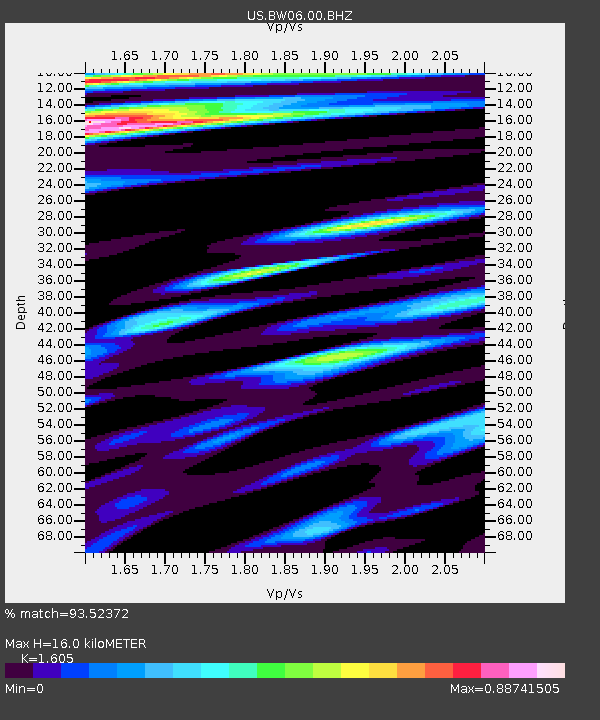
| Estimated Moho Depth: |
16.0 km |
| Estimated Crust Vp/Vs: |
1.61 |
| Assumed Crust Vp: |
6.161 km/s |
| Estimated Crust Vs: |
3.839 km/s |
| Estimated Crust Poisson's Ratio: |
0.18 |
|
| Radial Match: |
93.52372 % |
| Radial Bump: |
400 |
| Transverse Match: |
91.67466 % |
| Transverse Bump: |
400 |
| SOD ConfigId: |
30536071 |
| Insert Time: |
2023-06-29 19:08:43.615 +0000 |
| GWidth: |
2.5 |
| Max Bumps: |
400 |
| Tol: |
0.001 |
|
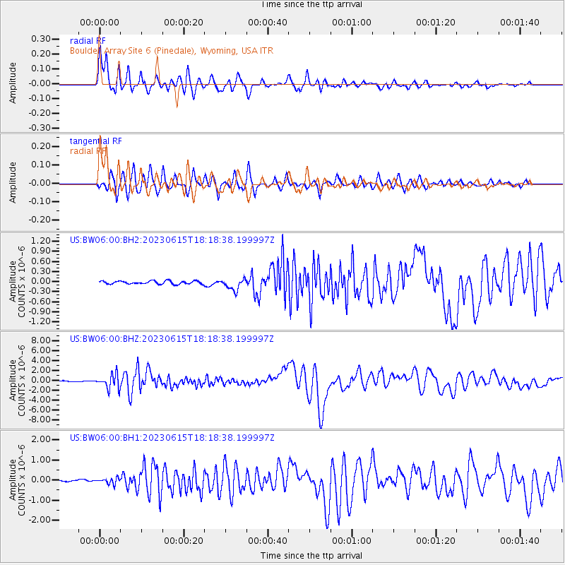
Signal To Noise
| Channel | StoN | STA | LTA |
| US:BW06:00:BHZ:20230615T18:18:38.199997Z | 16.251944 | 1.4448576E-6 | 8.890368E-8 |
| US:BW06:00:BH1:20230615T18:18:38.199997Z | 3.1902926 | 1.4155108E-7 | 4.436931E-8 |
| US:BW06:00:BH2:20230615T18:18:38.199997Z | 3.8569825 | 1.7408352E-7 | 4.5134644E-8 |
| Arrivals |
| Ps | 1.6 SECOND |
| PpPs | 6.6 SECOND |
| PsPs/PpSs | 8.2 SECOND |


