You are here: Home > Network List > US - United States National Seismic Network Stations List
> Station CBKS Cedar Bluff, Kansas, USA > Earthquake Result Viewer
CBKS Cedar Bluff, Kansas, USA - Earthquake Result Viewer
| Earthquake location: |
South Of Fiji Islands |
| Earthquake latitude/longitude: |
-23.0/-177.2 |
| Earthquake time(UTC): |
2023/06/15 (166) 18:06:27 GMT |
| Earthquake Depth: |
167 km |
| Earthquake Magnitude: |
7.2 Mww |
| Earthquake Catalog/Contributor: |
NEIC PDE/us |
|
| Network: |
US United States National Seismic Network |
| Station: |
CBKS Cedar Bluff, Kansas, USA |
| Lat/Lon: |
38.81 N/99.74 W |
| Elevation: |
677 m |
|
| Distance: |
94.9 deg |
| Az: |
49.949 deg |
| Baz: |
244.551 deg |
| Ray Param: |
0.040794887 |
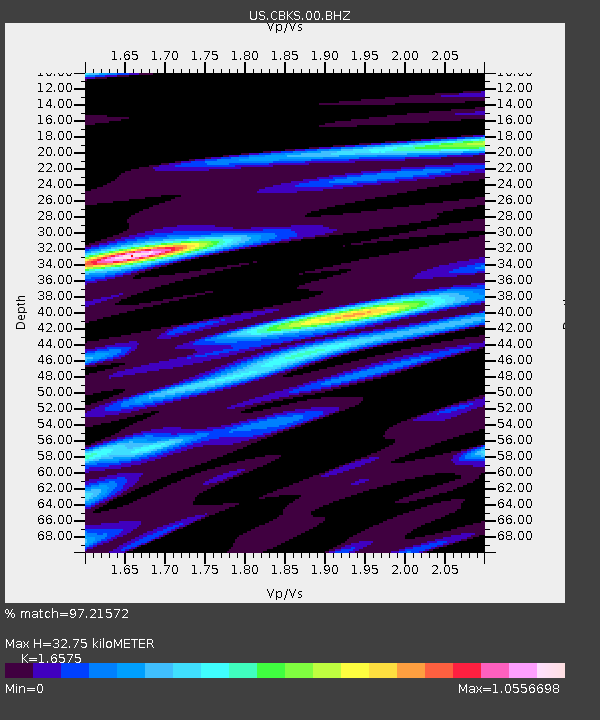
| Estimated Moho Depth: |
32.75 km |
| Estimated Crust Vp/Vs: |
1.66 |
| Assumed Crust Vp: |
6.483 km/s |
| Estimated Crust Vs: |
3.911 km/s |
| Estimated Crust Poisson's Ratio: |
0.21 |
|
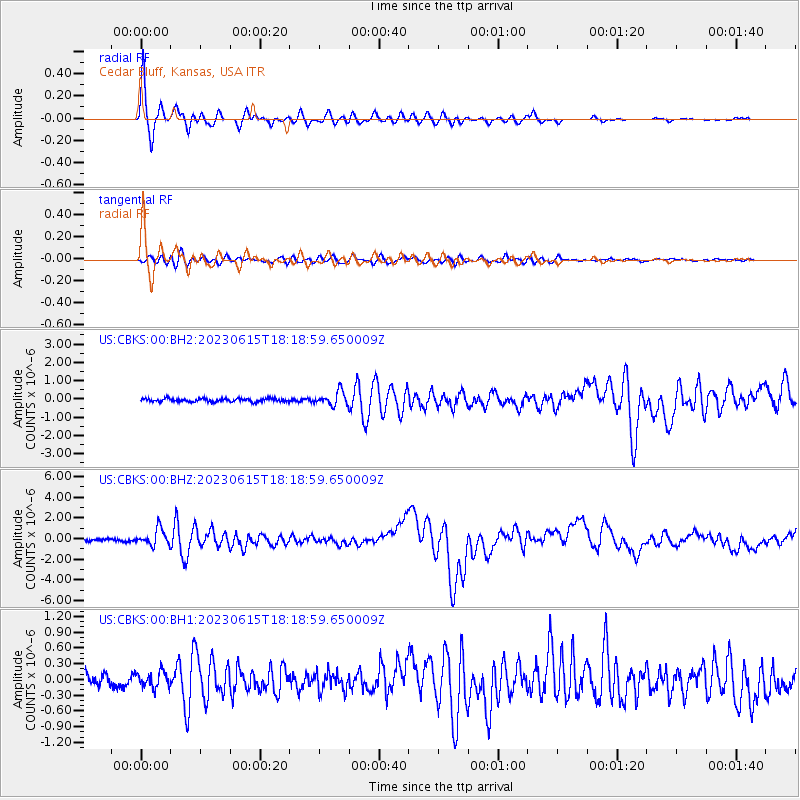
| Radial Match: |
97.21572 % |
| Radial Bump: |
318 |
| Transverse Match: |
75.76727 % |
| Transverse Bump: |
400 |
| SOD ConfigId: |
30536071 |
| Insert Time: |
2023-06-29 19:08:45.140 +0000 |
| GWidth: |
2.5 |
| Max Bumps: |
400 |
| Tol: |
0.001 |
|
Signal To Noise
| Channel | StoN | STA | LTA |
| US:CBKS:00:BHZ:20230615T18:18:59.650009Z | 8.665629 | 7.798907E-7 | 8.999815E-8 |
| US:CBKS:00:BH1:20230615T18:18:59.650009Z | 1.3285576 | 1.4991545E-7 | 1.12840766E-7 |
| US:CBKS:00:BH2:20230615T18:18:59.650009Z | 4.1975 | 3.776273E-7 | 8.996481E-8 |
| Arrivals |
| Ps | 3.4 SECOND |
| PpPs | 13 SECOND |
| PsPs/PpSs | 17 SECOND |


