You are here: Home > Network List > US - United States National Seismic Network Stations List
> Station OGNE Ogallala, Nebraska, USA > Earthquake Result Viewer
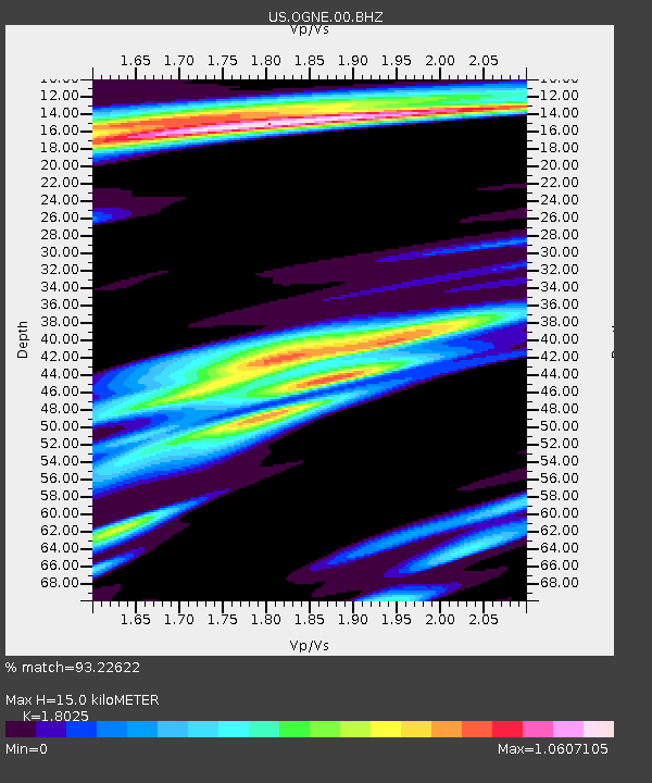
OGNE Ogallala, Nebraska, USA - Earthquake Result Viewer
| Earthquake location: |
South Of Fiji Islands |
| Earthquake latitude/longitude: |
-23.0/-177.2 |
| Earthquake time(UTC): |
2023/06/15 (166) 18:06:27 GMT |
| Earthquake Depth: |
167 km |
| Earthquake Magnitude: |
7.2 Mww |
| Earthquake Catalog/Contributor: |
NEIC PDE/us |
|
| Network: |
US United States National Seismic Network |
| Station: |
OGNE Ogallala, Nebraska, USA |
| Lat/Lon: |
40.95 N/102.03 W |
| Elevation: |
1054 m |
|
| Distance: |
94.3 deg |
| Az: |
47.252 deg |
| Baz: |
243.302 deg |
| Ray Param: |
0.04096117 |
| Estimated Moho Depth: |
15.0 km |
| Estimated Crust Vp/Vs: |
1.80 |
| Assumed Crust Vp: |
6.483 km/s |
| Estimated Crust Vs: |
3.596 km/s |
| Estimated Crust Poisson's Ratio: |
0.28 |
|
| Radial Match: |
93.22622 % |
| Radial Bump: |
346 |
| Transverse Match: |
73.2412 % |
| Transverse Bump: |
400 |
| SOD ConfigId: |
30536071 |
| Insert Time: |
2023-06-29 19:09:12.776 +0000 |
| GWidth: |
2.5 |
| Max Bumps: |
400 |
| Tol: |
0.001 |
|

Signal To Noise
| Channel | StoN | STA | LTA |
| US:OGNE:00:BHZ:20230615T18:18:56.69902Z | 10.183054 | 1.2942158E-6 | 1.2709505E-7 |
| US:OGNE:00:BH1:20230615T18:18:56.69902Z | 0.9452743 | 1.7533031E-7 | 1.8548089E-7 |
| US:OGNE:00:BH2:20230615T18:18:56.69902Z | 2.9392805 | 4.039515E-7 | 1.374321E-7 |
| Arrivals |
| Ps | 1.9 SECOND |
| PpPs | 6.4 SECOND |
| PsPs/PpSs | 8.3 SECOND |


