You are here: Home > Network List > TA - USArray Transportable Network (new EarthScope stations) Stations List
> Station BRSD Miller, SD, USA > Earthquake Result Viewer
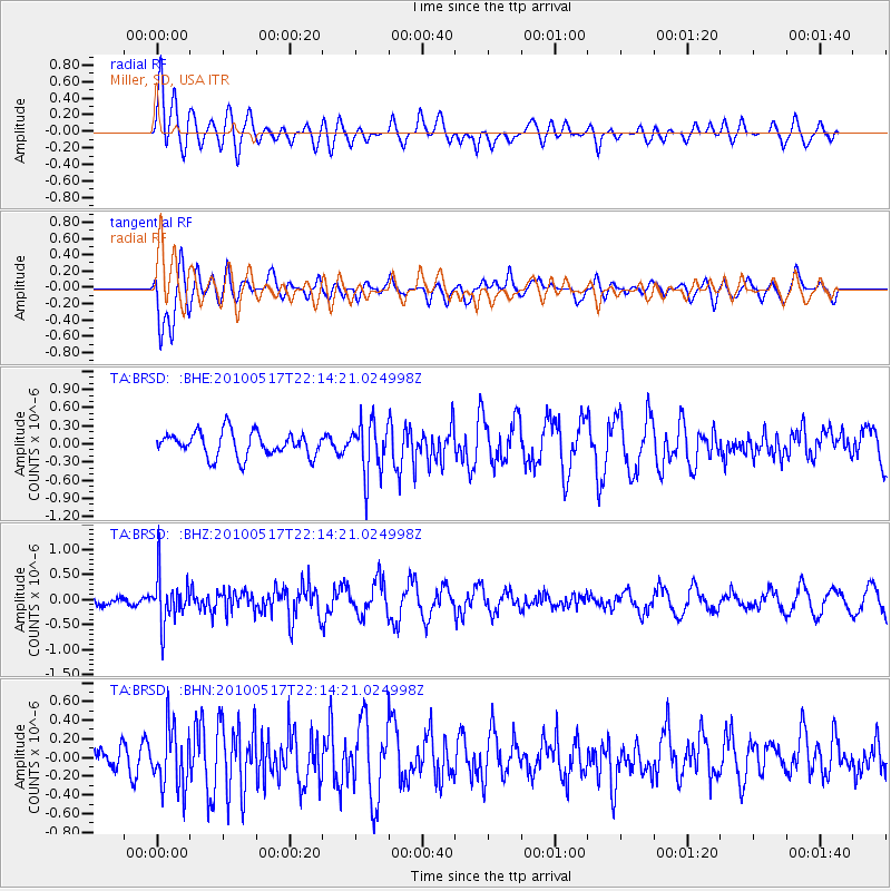
BRSD Miller, SD, USA - Earthquake Result Viewer
*The percent match for this event was below the threshold and hence no stack was calculated.
| Earthquake location: |
Kuril Islands |
| Earthquake latitude/longitude: |
46.3/152.0 |
| Earthquake time(UTC): |
2010/05/17 (137) 22:03:47 GMT |
| Earthquake Depth: |
73 km |
| Earthquake Magnitude: |
5.7 MB, 5.3 MW |
| Earthquake Catalog/Contributor: |
WHDF/NEIC |
|
| Network: |
TA USArray Transportable Network (new EarthScope stations) |
| Station: |
BRSD Miller, SD, USA |
| Lat/Lon: |
44.44 N/98.96 W |
| Elevation: |
519 m |
|
| Distance: |
70.1 deg |
| Az: |
46.078 deg |
| Baz: |
315.79 deg |
| Ray Param: |
$rayparam |
*The percent match for this event was below the threshold and hence was not used in the summary stack. |
|
| Radial Match: |
65.45985 % |
| Radial Bump: |
400 |
| Transverse Match: |
75.85772 % |
| Transverse Bump: |
400 |
| SOD ConfigId: |
314592 |
| Insert Time: |
2010-09-04 06:51:13.324 +0000 |
| GWidth: |
2.5 |
| Max Bumps: |
400 |
| Tol: |
0.001 |
|
Signal To Noise
| Channel | StoN | STA | LTA |
| TA:BRSD: :BHZ:20100517T22:14:21.024998Z | 5.5641284 | 4.6641952E-7 | 8.382616E-8 |
| TA:BRSD: :BHN:20100517T22:14:21.024998Z | 2.0925238 | 3.2646412E-7 | 1.5601454E-7 |
| TA:BRSD: :BHE:20100517T22:14:21.024998Z | 2.1708567 | 4.3195706E-7 | 1.9897999E-7 |
| Arrivals |
| Ps | |
| PpPs | |
| PsPs/PpSs | |


