You are here: Home > Network List > UU - University of Utah Regional Network Stations List
> Station MCU Monte Cristo, UT, USA > Earthquake Result Viewer
MCU Monte Cristo, UT, USA - Earthquake Result Viewer
| Earthquake location: |
South Of Fiji Islands |
| Earthquake latitude/longitude: |
-23.0/-177.2 |
| Earthquake time(UTC): |
2023/06/15 (166) 18:06:27 GMT |
| Earthquake Depth: |
167 km |
| Earthquake Magnitude: |
7.2 Mww |
| Earthquake Catalog/Contributor: |
NEIC PDE/us |
|
| Network: |
UU University of Utah Regional Network |
| Station: |
MCU Monte Cristo, UT, USA |
| Lat/Lon: |
41.46 N/111.51 W |
| Elevation: |
2668 m |
|
| Distance: |
88.3 deg |
| Az: |
43.259 deg |
| Baz: |
237.168 deg |
| Ray Param: |
0.04227953 |
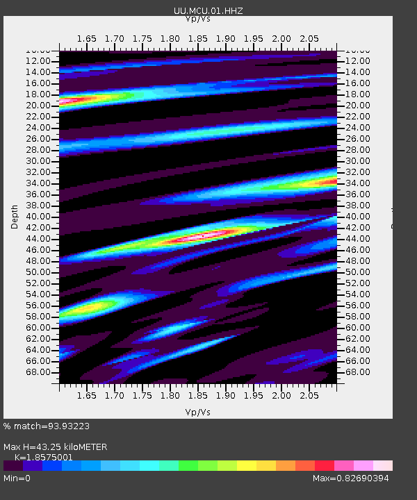
| Estimated Moho Depth: |
43.25 km |
| Estimated Crust Vp/Vs: |
1.86 |
| Assumed Crust Vp: |
6.155 km/s |
| Estimated Crust Vs: |
3.314 km/s |
| Estimated Crust Poisson's Ratio: |
0.30 |
|
| Radial Match: |
93.93223 % |
| Radial Bump: |
381 |
| Transverse Match: |
93.01454 % |
| Transverse Bump: |
285 |
| SOD ConfigId: |
30536071 |
| Insert Time: |
2023-06-29 19:09:51.700 +0000 |
| GWidth: |
2.5 |
| Max Bumps: |
400 |
| Tol: |
0.001 |
|

Signal To Noise
| Channel | StoN | STA | LTA |
| UU:MCU:01:HHZ:20230615T18:18:29.270004Z | 23.024801 | 1.164561E-6 | 5.057855E-8 |
| UU:MCU:01:HHN:20230615T18:18:29.270004Z | 3.254963 | 1.3906326E-7 | 4.2723453E-8 |
| UU:MCU:01:HHE:20230615T18:18:29.270004Z | 5.367288 | 3.192997E-7 | 5.9489953E-8 |
| Arrivals |
| Ps | 6.1 SECOND |
| PpPs | 20 SECOND |
| PsPs/PpSs | 26 SECOND |


