You are here: Home > Network List > UW - Pacific Northwest Regional Seismic Network Stations List
> Station DY2 Dyer Hill 2, WA, USA > Earthquake Result Viewer
DY2 Dyer Hill 2, WA, USA - Earthquake Result Viewer
| Earthquake location: |
South Of Fiji Islands |
| Earthquake latitude/longitude: |
-23.0/-177.2 |
| Earthquake time(UTC): |
2023/06/15 (166) 18:06:27 GMT |
| Earthquake Depth: |
167 km |
| Earthquake Magnitude: |
7.2 Mww |
| Earthquake Catalog/Contributor: |
NEIC PDE/us |
|
| Network: |
UW Pacific Northwest Regional Seismic Network |
| Station: |
DY2 Dyer Hill 2, WA, USA |
| Lat/Lon: |
47.99 N/119.77 W |
| Elevation: |
892 m |
|
| Distance: |
87.4 deg |
| Az: |
34.526 deg |
| Baz: |
231.031 deg |
| Ray Param: |
0.042988077 |
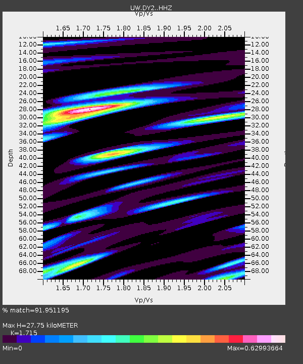
| Estimated Moho Depth: |
27.75 km |
| Estimated Crust Vp/Vs: |
1.72 |
| Assumed Crust Vp: |
6.419 km/s |
| Estimated Crust Vs: |
3.743 km/s |
| Estimated Crust Poisson's Ratio: |
0.24 |
|
| Radial Match: |
91.951195 % |
| Radial Bump: |
400 |
| Transverse Match: |
89.73931 % |
| Transverse Bump: |
400 |
| SOD ConfigId: |
30536071 |
| Insert Time: |
2023-06-29 19:11:00.059 +0000 |
| GWidth: |
2.5 |
| Max Bumps: |
400 |
| Tol: |
0.001 |
|

Signal To Noise
| Channel | StoN | STA | LTA |
| UW:DY2: :HHZ:20230615T18:18:24.739975Z | 62.152298 | 3.564656E-6 | 5.7353567E-8 |
| UW:DY2: :HHN:20230615T18:18:24.739975Z | 8.111941 | 6.329149E-7 | 7.8022616E-8 |
| UW:DY2: :HHE:20230615T18:18:24.739975Z | 8.035766 | 9.069042E-7 | 1.1285846E-7 |
| Arrivals |
| Ps | 3.2 SECOND |
| PpPs | 11 SECOND |
| PsPs/PpSs | 15 SECOND |


