You are here: Home > Network List > TA - USArray Transportable Network (new EarthScope stations) Stations List
> Station N27A Anderson Farm, Haxtun, CO, USA > Earthquake Result Viewer
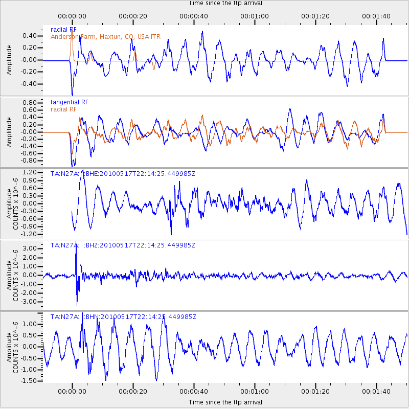
N27A Anderson Farm, Haxtun, CO, USA - Earthquake Result Viewer
*The percent match for this event was below the threshold and hence no stack was calculated.
| Earthquake location: |
Kuril Islands |
| Earthquake latitude/longitude: |
46.3/152.0 |
| Earthquake time(UTC): |
2010/05/17 (137) 22:03:47 GMT |
| Earthquake Depth: |
73 km |
| Earthquake Magnitude: |
5.7 MB, 5.3 MW |
| Earthquake Catalog/Contributor: |
WHDF/NEIC |
|
| Network: |
TA USArray Transportable Network (new EarthScope stations) |
| Station: |
N27A Anderson Farm, Haxtun, CO, USA |
| Lat/Lon: |
40.81 N/102.54 W |
| Elevation: |
1228 m |
|
| Distance: |
70.8 deg |
| Az: |
50.783 deg |
| Baz: |
314.949 deg |
| Ray Param: |
$rayparam |
*The percent match for this event was below the threshold and hence was not used in the summary stack. |
|
| Radial Match: |
44.48645 % |
| Radial Bump: |
400 |
| Transverse Match: |
51.843044 % |
| Transverse Bump: |
400 |
| SOD ConfigId: |
314592 |
| Insert Time: |
2010-09-04 06:53:06.374 +0000 |
| GWidth: |
2.5 |
| Max Bumps: |
400 |
| Tol: |
0.001 |
|
Signal To Noise
| Channel | StoN | STA | LTA |
| TA:N27A: :BHZ:20100517T22:14:25.449985Z | 8.13439 | 1.0801008E-6 | 1.3278203E-7 |
| TA:N27A: :BHN:20100517T22:14:25.449985Z | 1.0260075 | 5.5441393E-7 | 5.403605E-7 |
| TA:N27A: :BHE:20100517T22:14:25.449985Z | 0.8174325 | 4.0168356E-7 | 4.9139663E-7 |
| Arrivals |
| Ps | |
| PpPs | |
| PsPs/PpSs | |


