You are here: Home > Network List > UW - Pacific Northwest Regional Seismic Network Stations List
> Station LCV Les Collines Vineyard, Walla Walla, WA, USA > Earthquake Result Viewer
LCV Les Collines Vineyard, Walla Walla, WA, USA - Earthquake Result Viewer
| Earthquake location: |
South Of Fiji Islands |
| Earthquake latitude/longitude: |
-23.0/-177.2 |
| Earthquake time(UTC): |
2023/06/15 (166) 18:06:27 GMT |
| Earthquake Depth: |
167 km |
| Earthquake Magnitude: |
7.2 Mww |
| Earthquake Catalog/Contributor: |
NEIC PDE/us |
|
| Network: |
UW Pacific Northwest Regional Seismic Network |
| Station: |
LCV Les Collines Vineyard, Walla Walla, WA, USA |
| Lat/Lon: |
46.01 N/118.28 W |
| Elevation: |
361 m |
|
| Distance: |
87.0 deg |
| Az: |
36.714 deg |
| Baz: |
232.23 deg |
| Ray Param: |
0.043296497 |
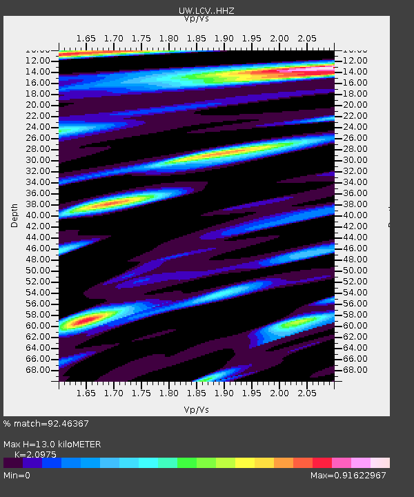
| Estimated Moho Depth: |
13.0 km |
| Estimated Crust Vp/Vs: |
2.10 |
| Assumed Crust Vp: |
6.419 km/s |
| Estimated Crust Vs: |
3.06 km/s |
| Estimated Crust Poisson's Ratio: |
0.35 |
|
| Radial Match: |
92.46367 % |
| Radial Bump: |
400 |
| Transverse Match: |
85.74479 % |
| Transverse Bump: |
400 |
| SOD ConfigId: |
30536071 |
| Insert Time: |
2023-06-29 19:11:53.691 +0000 |
| GWidth: |
2.5 |
| Max Bumps: |
400 |
| Tol: |
0.001 |
|

Signal To Noise
| Channel | StoN | STA | LTA |
| UW:LCV: :HHZ:20230615T18:18:22.699997Z | 17.06223 | 2.2830422E-6 | 1.338068E-7 |
| UW:LCV: :HHN:20230615T18:18:22.699997Z | 3.584058 | 4.374289E-7 | 1.220485E-7 |
| UW:LCV: :HHE:20230615T18:18:22.699997Z | 5.123592 | 5.3170163E-7 | 1.0377518E-7 |
| Arrivals |
| Ps | 2.3 SECOND |
| PpPs | 6.2 SECOND |
| PsPs/PpSs | 8.4 SECOND |


