You are here: Home > Network List > UW - Pacific Northwest Regional Seismic Network Stations List
> Station SHW Mt. St. Helens West, WA, USA > Earthquake Result Viewer
SHW Mt. St. Helens West, WA, USA - Earthquake Result Viewer
| Earthquake location: |
South Of Fiji Islands |
| Earthquake latitude/longitude: |
-23.0/-177.2 |
| Earthquake time(UTC): |
2023/06/15 (166) 18:06:27 GMT |
| Earthquake Depth: |
167 km |
| Earthquake Magnitude: |
7.2 Mww |
| Earthquake Catalog/Contributor: |
NEIC PDE/us |
|
| Network: |
UW Pacific Northwest Regional Seismic Network |
| Station: |
SHW Mt. St. Helens West, WA, USA |
| Lat/Lon: |
46.19 N/122.23 W |
| Elevation: |
1442 m |
|
| Distance: |
84.9 deg |
| Az: |
34.823 deg |
| Baz: |
229.253 deg |
| Ray Param: |
0.044732545 |
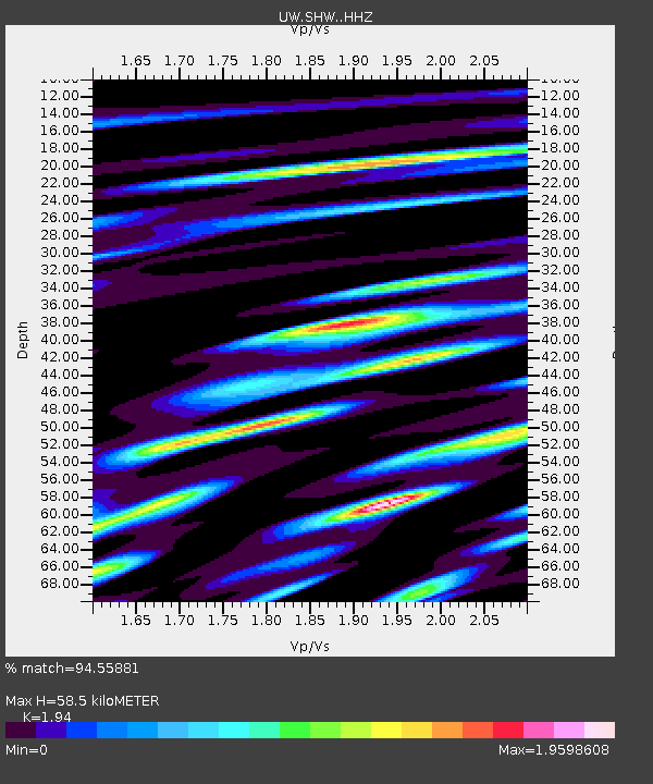
| Estimated Moho Depth: |
58.5 km |
| Estimated Crust Vp/Vs: |
1.94 |
| Assumed Crust Vp: |
6.566 km/s |
| Estimated Crust Vs: |
3.385 km/s |
| Estimated Crust Poisson's Ratio: |
0.32 |
|
| Radial Match: |
94.55881 % |
| Radial Bump: |
400 |
| Transverse Match: |
95.02526 % |
| Transverse Bump: |
400 |
| SOD ConfigId: |
30536071 |
| Insert Time: |
2023-06-29 19:13:11.136 +0000 |
| GWidth: |
2.5 |
| Max Bumps: |
400 |
| Tol: |
0.001 |
|

Signal To Noise
| Channel | StoN | STA | LTA |
| UW:SHW: :HHZ:20230615T18:18:12.85997Z | 35.07039 | 6.982876E-6 | 1.9911032E-7 |
| UW:SHW: :HHN:20230615T18:18:12.85997Z | 9.339127 | 3.7332475E-6 | 3.997427E-7 |
| UW:SHW: :HHE:20230615T18:18:12.85997Z | 7.8506126 | 2.1648686E-6 | 2.757579E-7 |
| Arrivals |
| Ps | 8.6 SECOND |
| PpPs | 26 SECOND |
| PsPs/PpSs | 34 SECOND |


