You are here: Home > Network List > UW - Pacific Northwest Regional Seismic Network Stations List
> Station SKOKO Rock Peak, WA, USA > Earthquake Result Viewer
SKOKO Rock Peak, WA, USA - Earthquake Result Viewer
| Earthquake location: |
South Of Fiji Islands |
| Earthquake latitude/longitude: |
-23.0/-177.2 |
| Earthquake time(UTC): |
2023/06/15 (166) 18:06:27 GMT |
| Earthquake Depth: |
167 km |
| Earthquake Magnitude: |
7.2 Mww |
| Earthquake Catalog/Contributor: |
NEIC PDE/us |
|
| Network: |
UW Pacific Northwest Regional Seismic Network |
| Station: |
SKOKO Rock Peak, WA, USA |
| Lat/Lon: |
47.41 N/123.37 W |
| Elevation: |
950 m |
|
| Distance: |
85.2 deg |
| Az: |
33.391 deg |
| Baz: |
228.307 deg |
| Ray Param: |
0.044577952 |
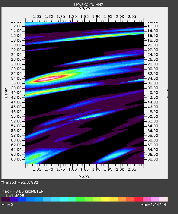
| Estimated Moho Depth: |
34.0 km |
| Estimated Crust Vp/Vs: |
1.69 |
| Assumed Crust Vp: |
6.566 km/s |
| Estimated Crust Vs: |
3.88 km/s |
| Estimated Crust Poisson's Ratio: |
0.23 |
|
| Radial Match: |
93.67982 % |
| Radial Bump: |
400 |
| Transverse Match: |
91.20755 % |
| Transverse Bump: |
400 |
| SOD ConfigId: |
30536071 |
| Insert Time: |
2023-06-29 19:13:14.525 +0000 |
| GWidth: |
2.5 |
| Max Bumps: |
400 |
| Tol: |
0.001 |
|

Signal To Noise
| Channel | StoN | STA | LTA |
| UW:SKOKO: :HHZ:20230615T18:18:13.929977Z | 19.602736 | 3.8051248E-6 | 1.9411193E-7 |
| UW:SKOKO: :HHN:20230615T18:18:13.929977Z | 13.463865 | 1.6434295E-6 | 1.2206225E-7 |
| UW:SKOKO: :HHE:20230615T18:18:13.929977Z | 2.4247994 | 5.4344497E-7 | 2.2411955E-7 |
| Arrivals |
| Ps | 3.7 SECOND |
| PpPs | 14 SECOND |
| PsPs/PpSs | 17 SECOND |


