You are here: Home > Network List > UW - Pacific Northwest Regional Seismic Network Stations List
> Station TREE Summer Lake, OR, USA > Earthquake Result Viewer
TREE Summer Lake, OR, USA - Earthquake Result Viewer
| Earthquake location: |
South Of Fiji Islands |
| Earthquake latitude/longitude: |
-23.0/-177.2 |
| Earthquake time(UTC): |
2023/06/15 (166) 18:06:27 GMT |
| Earthquake Depth: |
167 km |
| Earthquake Magnitude: |
7.2 Mww |
| Earthquake Catalog/Contributor: |
NEIC PDE/us |
|
| Network: |
UW Pacific Northwest Regional Seismic Network |
| Station: |
TREE Summer Lake, OR, USA |
| Lat/Lon: |
42.73 N/120.89 W |
| Elevation: |
1881 m |
|
| Distance: |
83.4 deg |
| Az: |
38.111 deg |
| Baz: |
230.522 deg |
| Ray Param: |
0.045787223 |
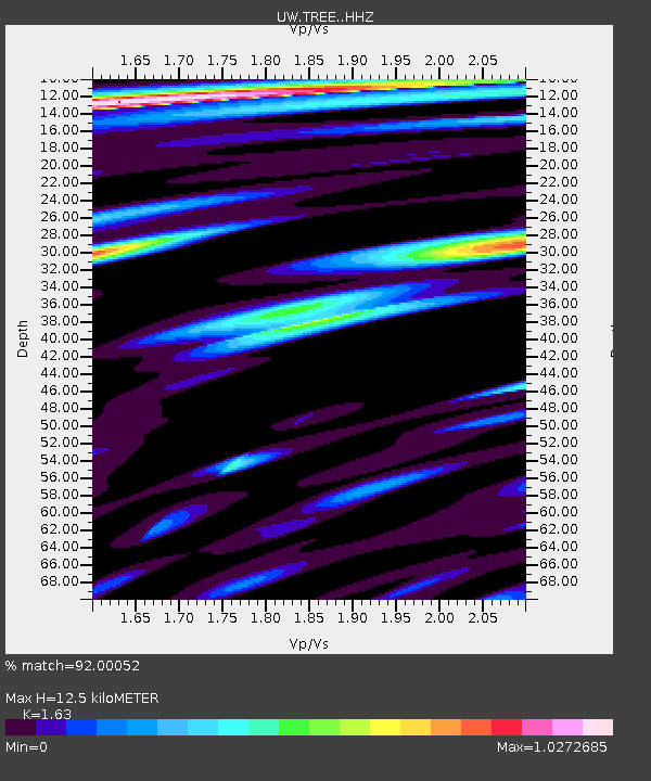
| Estimated Moho Depth: |
12.5 km |
| Estimated Crust Vp/Vs: |
1.63 |
| Assumed Crust Vp: |
6.597 km/s |
| Estimated Crust Vs: |
4.048 km/s |
| Estimated Crust Poisson's Ratio: |
0.20 |
|
| Radial Match: |
92.00052 % |
| Radial Bump: |
400 |
| Transverse Match: |
82.25334 % |
| Transverse Bump: |
400 |
| SOD ConfigId: |
30536071 |
| Insert Time: |
2023-06-29 19:13:38.402 +0000 |
| GWidth: |
2.5 |
| Max Bumps: |
400 |
| Tol: |
0.001 |
|
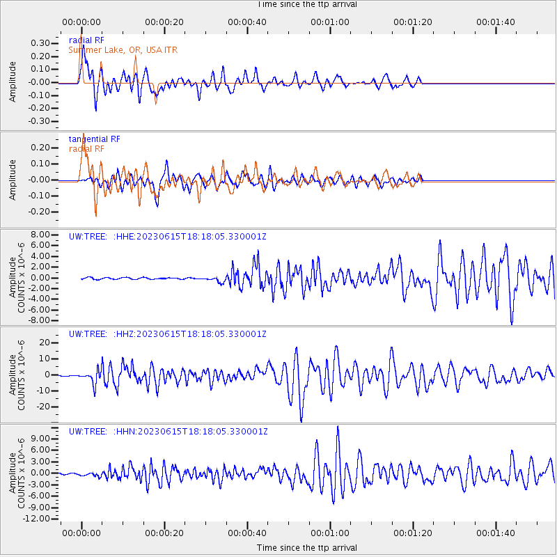
Signal To Noise
| Channel | StoN | STA | LTA |
| UW:TREE: :HHZ:20230615T18:18:05.330001Z | 17.248667 | 3.9216175E-6 | 2.2735772E-7 |
| UW:TREE: :HHN:20230615T18:18:05.330001Z | 1.7699645 | 4.4446114E-7 | 2.5111302E-7 |
| UW:TREE: :HHE:20230615T18:18:05.330001Z | 3.3357513 | 5.18717E-7 | 1.5550229E-7 |
| Arrivals |
| Ps | 1.2 SECOND |
| PpPs | 4.8 SECOND |
| PsPs/PpSs | 6.1 SECOND |


