You are here: Home > Network List > UW - Pacific Northwest Regional Seismic Network Stations List
> Station UMAT Pilot Rock, OR, USA > Earthquake Result Viewer
UMAT Pilot Rock, OR, USA - Earthquake Result Viewer
| Earthquake location: |
South Of Fiji Islands |
| Earthquake latitude/longitude: |
-23.0/-177.2 |
| Earthquake time(UTC): |
2023/06/15 (166) 18:06:27 GMT |
| Earthquake Depth: |
167 km |
| Earthquake Magnitude: |
7.2 Mww |
| Earthquake Catalog/Contributor: |
NEIC PDE/us |
|
| Network: |
UW Pacific Northwest Regional Seismic Network |
| Station: |
UMAT Pilot Rock, OR, USA |
| Lat/Lon: |
45.29 N/118.96 W |
| Elevation: |
1318 m |
|
| Distance: |
86.1 deg |
| Az: |
36.986 deg |
| Baz: |
231.759 deg |
| Ray Param: |
0.043886364 |
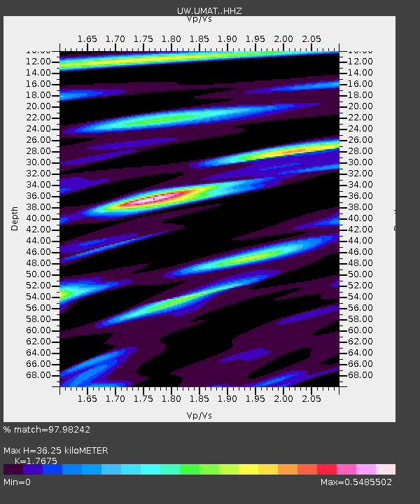
| Estimated Moho Depth: |
36.25 km |
| Estimated Crust Vp/Vs: |
1.77 |
| Assumed Crust Vp: |
6.571 km/s |
| Estimated Crust Vs: |
3.718 km/s |
| Estimated Crust Poisson's Ratio: |
0.26 |
|
| Radial Match: |
97.98242 % |
| Radial Bump: |
303 |
| Transverse Match: |
96.114265 % |
| Transverse Bump: |
400 |
| SOD ConfigId: |
30536071 |
| Insert Time: |
2023-06-29 19:13:42.880 +0000 |
| GWidth: |
2.5 |
| Max Bumps: |
400 |
| Tol: |
0.001 |
|

Signal To Noise
| Channel | StoN | STA | LTA |
| UW:UMAT: :HHZ:20230615T18:18:18.739975Z | 49.455067 | 3.205728E-6 | 6.482102E-8 |
| UW:UMAT: :HHN:20230615T18:18:18.739975Z | 14.220957 | 8.355673E-7 | 5.875605E-8 |
| UW:UMAT: :HHE:20230615T18:18:18.739975Z | 17.129404 | 8.9913163E-7 | 5.2490538E-8 |
| Arrivals |
| Ps | 4.3 SECOND |
| PpPs | 15 SECOND |
| PsPs/PpSs | 19 SECOND |


