You are here: Home > Network List > TA - USArray Transportable Network (new EarthScope stations) Stations List
> Station P30A Selden, KS, USA > Earthquake Result Viewer
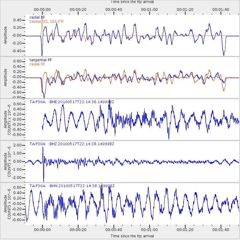
P30A Selden, KS, USA - Earthquake Result Viewer
*The percent match for this event was below the threshold and hence no stack was calculated.
| Earthquake location: |
Kuril Islands |
| Earthquake latitude/longitude: |
46.3/152.0 |
| Earthquake time(UTC): |
2010/05/17 (137) 22:03:47 GMT |
| Earthquake Depth: |
73 km |
| Earthquake Magnitude: |
5.7 MB, 5.3 MW |
| Earthquake Catalog/Contributor: |
WHDF/NEIC |
|
| Network: |
TA USArray Transportable Network (new EarthScope stations) |
| Station: |
P30A Selden, KS, USA |
| Lat/Lon: |
39.54 N/100.25 W |
| Elevation: |
788 m |
|
| Distance: |
72.9 deg |
| Az: |
50.391 deg |
| Baz: |
316.298 deg |
| Ray Param: |
$rayparam |
*The percent match for this event was below the threshold and hence was not used in the summary stack. |
|
| Radial Match: |
60.27526 % |
| Radial Bump: |
400 |
| Transverse Match: |
76.9551 % |
| Transverse Bump: |
400 |
| SOD ConfigId: |
314592 |
| Insert Time: |
2010-09-04 06:57:21.083 +0000 |
| GWidth: |
2.5 |
| Max Bumps: |
400 |
| Tol: |
0.001 |
|
Signal To Noise
| Channel | StoN | STA | LTA |
| TA:P30A: :BHZ:20100517T22:14:38.149998Z | 5.4223847 | 6.5767745E-7 | 1.2128933E-7 |
| TA:P30A: :BHN:20100517T22:14:38.149998Z | 0.95252454 | 3.0749536E-7 | 3.2282145E-7 |
| TA:P30A: :BHE:20100517T22:14:38.149998Z | 1.0317745 | 2.6122635E-7 | 2.5318164E-7 |
| Arrivals |
| Ps | |
| PpPs | |
| PsPs/PpSs | |


