You are here: Home > Network List > TA - USArray Transportable Network (new EarthScope stations) Stations List
> Station A26A Wade Farm, Kenmare, ND, USA > Earthquake Result Viewer
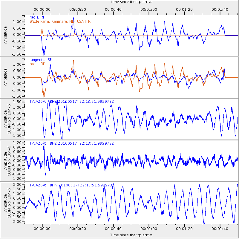
A26A Wade Farm, Kenmare, ND, USA - Earthquake Result Viewer
*The percent match for this event was below the threshold and hence no stack was calculated.
| Earthquake location: |
Kuril Islands |
| Earthquake latitude/longitude: |
46.3/152.0 |
| Earthquake time(UTC): |
2010/05/17 (137) 22:03:47 GMT |
| Earthquake Depth: |
73 km |
| Earthquake Magnitude: |
5.7 MB, 5.3 MW |
| Earthquake Catalog/Contributor: |
WHDF/NEIC |
|
| Network: |
TA USArray Transportable Network (new EarthScope stations) |
| Station: |
A26A Wade Farm, Kenmare, ND, USA |
| Lat/Lon: |
48.90 N/102.04 W |
| Elevation: |
570 m |
|
| Distance: |
65.4 deg |
| Az: |
44.237 deg |
| Baz: |
312.856 deg |
| Ray Param: |
$rayparam |
*The percent match for this event was below the threshold and hence was not used in the summary stack. |
|
| Radial Match: |
56.91965 % |
| Radial Bump: |
400 |
| Transverse Match: |
33.033348 % |
| Transverse Bump: |
400 |
| SOD ConfigId: |
314592 |
| Insert Time: |
2010-09-04 06:59:42.082 +0000 |
| GWidth: |
2.5 |
| Max Bumps: |
400 |
| Tol: |
0.001 |
|
Signal To Noise
| Channel | StoN | STA | LTA |
| TA:A26A: :BHZ:20100517T22:13:51.999973Z | 2.5922253 | 4.988402E-7 | 1.9243706E-7 |
| TA:A26A: :BHN:20100517T22:13:51.999973Z | 0.614389 | 6.7868547E-7 | 1.104651E-6 |
| TA:A26A: :BHE:20100517T22:13:51.999973Z | 0.58891493 | 5.1623164E-7 | 8.7658094E-7 |
| Arrivals |
| Ps | |
| PpPs | |
| PsPs/PpSs | |


