You are here: Home > Network List > TA - USArray Transportable Network (new EarthScope stations) Stations List
> Station E29A Napoleon, ND, USA > Earthquake Result Viewer
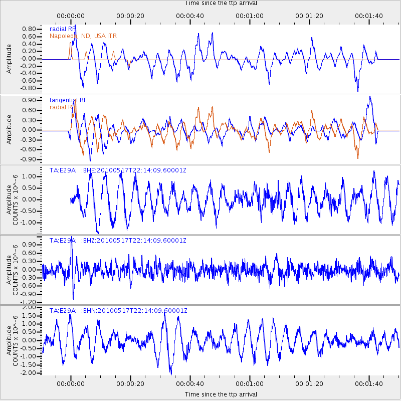
E29A Napoleon, ND, USA - Earthquake Result Viewer
*The percent match for this event was below the threshold and hence no stack was calculated.
| Earthquake location: |
Kuril Islands |
| Earthquake latitude/longitude: |
46.3/152.0 |
| Earthquake time(UTC): |
2010/05/17 (137) 22:03:47 GMT |
| Earthquake Depth: |
73 km |
| Earthquake Magnitude: |
5.7 MB, 5.3 MW |
| Earthquake Catalog/Contributor: |
WHDF/NEIC |
|
| Network: |
TA USArray Transportable Network (new EarthScope stations) |
| Station: |
E29A Napoleon, ND, USA |
| Lat/Lon: |
46.57 N/99.64 W |
| Elevation: |
628 m |
|
| Distance: |
68.2 deg |
| Az: |
44.846 deg |
| Baz: |
314.864 deg |
| Ray Param: |
$rayparam |
*The percent match for this event was below the threshold and hence was not used in the summary stack. |
|
| Radial Match: |
48.670696 % |
| Radial Bump: |
368 |
| Transverse Match: |
49.494385 % |
| Transverse Bump: |
376 |
| SOD ConfigId: |
314592 |
| Insert Time: |
2010-09-04 07:00:56.074 +0000 |
| GWidth: |
2.5 |
| Max Bumps: |
400 |
| Tol: |
0.001 |
|
Signal To Noise
| Channel | StoN | STA | LTA |
| TA:E29A: :BHZ:20100517T22:14:09.60001Z | 2.2642732 | 4.613663E-7 | 2.0375911E-7 |
| TA:E29A: :BHN:20100517T22:14:09.60001Z | 1.1565948 | 8.162743E-7 | 7.0575646E-7 |
| TA:E29A: :BHE:20100517T22:14:09.60001Z | 0.6897534 | 4.9331356E-7 | 7.152028E-7 |
| Arrivals |
| Ps | |
| PpPs | |
| PsPs/PpSs | |


