You are here: Home > Network List > TA - USArray Transportable Network (new EarthScope stations) Stations List
> Station B29A Wagenman Farm, Cando, ND, USA > Earthquake Result Viewer
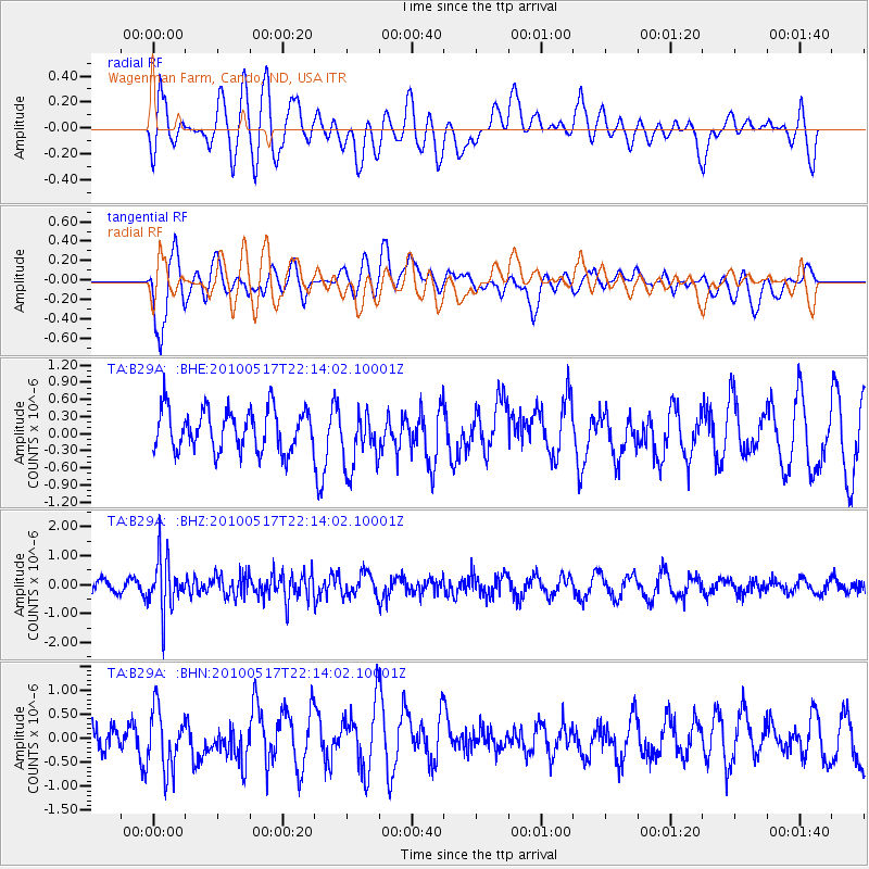
B29A Wagenman Farm, Cando, ND, USA - Earthquake Result Viewer
*The percent match for this event was below the threshold and hence no stack was calculated.
| Earthquake location: |
Kuril Islands |
| Earthquake latitude/longitude: |
46.3/152.0 |
| Earthquake time(UTC): |
2010/05/17 (137) 22:03:47 GMT |
| Earthquake Depth: |
73 km |
| Earthquake Magnitude: |
5.7 MB, 5.3 MW |
| Earthquake Catalog/Contributor: |
WHDF/NEIC |
|
| Network: |
TA USArray Transportable Network (new EarthScope stations) |
| Station: |
B29A Wagenman Farm, Cando, ND, USA |
| Lat/Lon: |
48.46 N/99.35 W |
| Elevation: |
460 m |
|
| Distance: |
67.0 deg |
| Az: |
43.237 deg |
| Baz: |
314.464 deg |
| Ray Param: |
$rayparam |
*The percent match for this event was below the threshold and hence was not used in the summary stack. |
|
| Radial Match: |
57.47605 % |
| Radial Bump: |
400 |
| Transverse Match: |
73.3997 % |
| Transverse Bump: |
400 |
| SOD ConfigId: |
314592 |
| Insert Time: |
2010-09-04 07:01:20.246 +0000 |
| GWidth: |
2.5 |
| Max Bumps: |
400 |
| Tol: |
0.001 |
|
Signal To Noise
| Channel | StoN | STA | LTA |
| TA:B29A: :BHZ:20100517T22:14:02.10001Z | 3.7581568 | 9.3030593E-7 | 2.4754314E-7 |
| TA:B29A: :BHN:20100517T22:14:02.10001Z | 1.4405966 | 6.220491E-7 | 4.3179963E-7 |
| TA:B29A: :BHE:20100517T22:14:02.10001Z | 1.421734 | 5.1152233E-7 | 3.5978766E-7 |
| Arrivals |
| Ps | |
| PpPs | |
| PsPs/PpSs | |


