You are here: Home > Network List > GS - US Geological Survey Networks Stations List
> Station OK051 E0350 and S34600 Roads, Ralston, OK > Earthquake Result Viewer
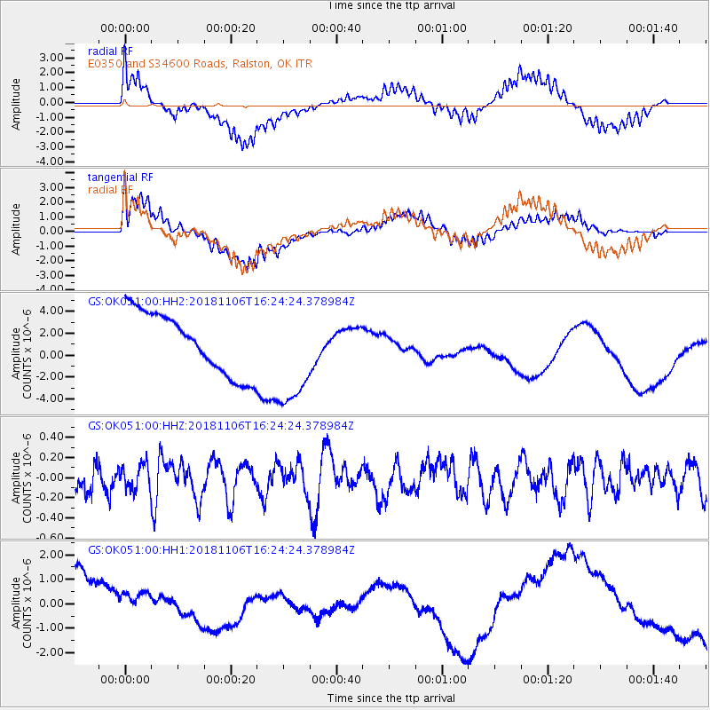
OK051 E0350 and S34600 Roads, Ralston, OK - Earthquake Result Viewer
*The percent match for this event was below the threshold and hence no stack was calculated.
| Earthquake location: |
Tonga Islands Region |
| Earthquake latitude/longitude: |
-22.2/-174.5 |
| Earthquake time(UTC): |
2018/11/06 (310) 16:11:39 GMT |
| Earthquake Depth: |
10 km |
| Earthquake Magnitude: |
5.5 Mww |
| Earthquake Catalog/Contributor: |
NEIC PDE/us |
|
| Network: |
GS US Geological Survey Networks |
| Station: |
OK051 E0350 and S34600 Roads, Ralston, OK |
| Lat/Lon: |
36.51 N/96.84 W |
| Elevation: |
263 m |
|
| Distance: |
93.6 deg |
| Az: |
52.071 deg |
| Baz: |
245.144 deg |
| Ray Param: |
$rayparam |
*The percent match for this event was below the threshold and hence was not used in the summary stack. |
|
| Radial Match: |
41.04738 % |
| Radial Bump: |
368 |
| Transverse Match: |
47.28924 % |
| Transverse Bump: |
400 |
| SOD ConfigId: |
3131071 |
| Insert Time: |
2018-11-20 16:24:04.116 +0000 |
| GWidth: |
2.5 |
| Max Bumps: |
400 |
| Tol: |
0.001 |
|
Signal To Noise
| Channel | StoN | STA | LTA |
| GS:OK051:00:HHZ:20181106T16:24:24.378984Z | 0.7569392 | 1.2044403E-7 | 1.5911982E-7 |
| GS:OK051:00:HH1:20181106T16:24:24.378984Z | 0.61544645 | 6.401469E-7 | 1.0401342E-6 |
| GS:OK051:00:HH2:20181106T16:24:24.378984Z | 1.7041882 | 4.7460626E-6 | 2.7849403E-6 |
| Arrivals |
| Ps | |
| PpPs | |
| PsPs/PpSs | |


