You are here: Home > Network List > IU - Global Seismograph Network (GSN - IRIS/USGS) Stations List
> Station PMG Port Moresby, New Guinea > Earthquake Result Viewer
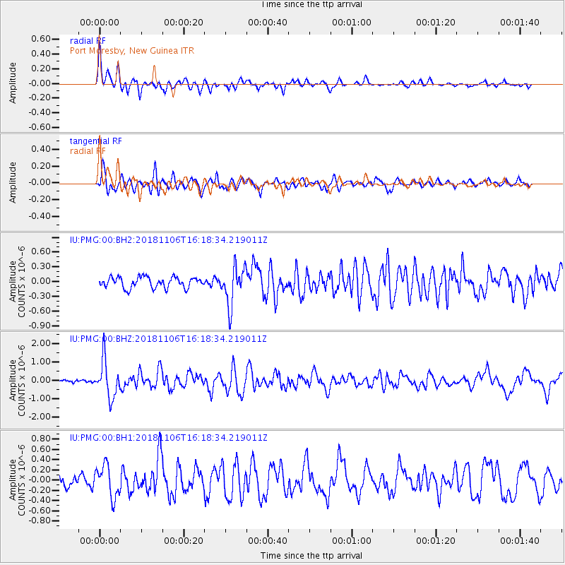
PMG Port Moresby, New Guinea - Earthquake Result Viewer
*The percent match for this event was below the threshold and hence no stack was calculated.
| Earthquake location: |
Tonga Islands Region |
| Earthquake latitude/longitude: |
-22.2/-174.5 |
| Earthquake time(UTC): |
2018/11/06 (310) 16:11:39 GMT |
| Earthquake Depth: |
10 km |
| Earthquake Magnitude: |
5.5 Mww |
| Earthquake Catalog/Contributor: |
NEIC PDE/us |
|
| Network: |
IU Global Seismograph Network (GSN - IRIS/USGS) |
| Station: |
PMG Port Moresby, New Guinea |
| Lat/Lon: |
9.40 S/147.16 E |
| Elevation: |
90 m |
|
| Distance: |
38.9 deg |
| Az: |
282.91 deg |
| Baz: |
113.714 deg |
| Ray Param: |
$rayparam |
*The percent match for this event was below the threshold and hence was not used in the summary stack. |
|
| Radial Match: |
83.439865 % |
| Radial Bump: |
400 |
| Transverse Match: |
78.06999 % |
| Transverse Bump: |
400 |
| SOD ConfigId: |
3131071 |
| Insert Time: |
2018-11-20 16:24:40.111 +0000 |
| GWidth: |
2.5 |
| Max Bumps: |
400 |
| Tol: |
0.001 |
|
Signal To Noise
| Channel | StoN | STA | LTA |
| IU:PMG:00:BHZ:20181106T16:18:34.219011Z | 8.563899 | 1.0173418E-6 | 1.1879423E-7 |
| IU:PMG:00:BH1:20181106T16:18:34.219011Z | 3.7068534 | 3.2030135E-7 | 8.640788E-8 |
| IU:PMG:00:BH2:20181106T16:18:34.219011Z | 3.6315055 | 3.976271E-7 | 1.0949373E-7 |
| Arrivals |
| Ps | |
| PpPs | |
| PsPs/PpSs | |


