You are here: Home > Network List > TX - Texas Seismological Network Stations List
> Station PB01 Permian Basin 1 > Earthquake Result Viewer
PB01 Permian Basin 1 - Earthquake Result Viewer
| Earthquake location: |
Tonga Islands Region |
| Earthquake latitude/longitude: |
-23.6/-175.9 |
| Earthquake time(UTC): |
2023/06/16 (167) 08:11:34 GMT |
| Earthquake Depth: |
22 km |
| Earthquake Magnitude: |
6.0 mww |
| Earthquake Catalog/Contributor: |
NEIC PDE/us |
|
| Network: |
TX Texas Seismological Network |
| Station: |
PB01 Permian Basin 1 |
| Lat/Lon: |
30.94 N/103.78 W |
| Elevation: |
1010 m |
|
| Distance: |
87.8 deg |
| Az: |
54.907 deg |
| Baz: |
240.903 deg |
| Ray Param: |
0.043061677 |
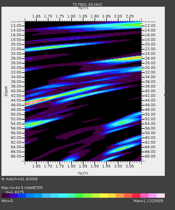
| Estimated Moho Depth: |
44.5 km |
| Estimated Crust Vp/Vs: |
1.64 |
| Assumed Crust Vp: |
6.121 km/s |
| Estimated Crust Vs: |
3.738 km/s |
| Estimated Crust Poisson's Ratio: |
0.20 |
|
| Radial Match: |
81.63459 % |
| Radial Bump: |
400 |
| Transverse Match: |
64.46065 % |
| Transverse Bump: |
400 |
| SOD ConfigId: |
30536071 |
| Insert Time: |
2023-06-30 08:36:16.479 +0000 |
| GWidth: |
2.5 |
| Max Bumps: |
400 |
| Tol: |
0.001 |
|

Signal To Noise
| Channel | StoN | STA | LTA |
| TX:PB01:00:HHZ:20230616T08:23:50.280028Z | 6.7082887 | 4.375502E-7 | 6.522531E-8 |
| TX:PB01:00:HH1:20230616T08:23:50.280028Z | 1.3961401 | 9.1198785E-8 | 6.5322084E-8 |
| TX:PB01:00:HH2:20230616T08:23:50.280028Z | 3.5302353 | 2.0446696E-7 | 5.791879E-8 |
| Arrivals |
| Ps | 4.7 SECOND |
| PpPs | 19 SECOND |
| PsPs/PpSs | 24 SECOND |


