You are here: Home > Network List > UU - University of Utah Regional Network Stations List
> Station CCUT Cedar City, UT, USA > Earthquake Result Viewer
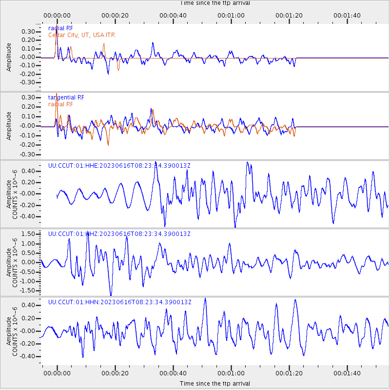
CCUT Cedar City, UT, USA - Earthquake Result Viewer
*The percent match for this event was below the threshold and hence no stack was calculated.
| Earthquake location: |
Tonga Islands Region |
| Earthquake latitude/longitude: |
-23.6/-175.9 |
| Earthquake time(UTC): |
2023/06/16 (167) 08:11:34 GMT |
| Earthquake Depth: |
22 km |
| Earthquake Magnitude: |
6.0 mww |
| Earthquake Catalog/Contributor: |
NEIC PDE/us |
|
| Network: |
UU University of Utah Regional Network |
| Station: |
CCUT Cedar City, UT, USA |
| Lat/Lon: |
37.55 N/113.36 W |
| Elevation: |
2127 m |
|
| Distance: |
84.5 deg |
| Az: |
45.099 deg |
| Baz: |
234.859 deg |
| Ray Param: |
$rayparam |
*The percent match for this event was below the threshold and hence was not used in the summary stack. |
|
| Radial Match: |
68.555855 % |
| Radial Bump: |
400 |
| Transverse Match: |
75.19263 % |
| Transverse Bump: |
400 |
| SOD ConfigId: |
30536071 |
| Insert Time: |
2023-06-30 08:39:10.818 +0000 |
| GWidth: |
2.5 |
| Max Bumps: |
400 |
| Tol: |
0.001 |
|
Signal To Noise
| Channel | StoN | STA | LTA |
| UU:CCUT:01:HHZ:20230616T08:23:34.390013Z | 2.8896277 | 4.4735194E-7 | 1.5481301E-7 |
| UU:CCUT:01:HHN:20230616T08:23:34.390013Z | 0.30511448 | 5.4306255E-8 | 1.779865E-7 |
| UU:CCUT:01:HHE:20230616T08:23:34.390013Z | 2.8822317 | 2.7189424E-7 | 9.4334624E-8 |
| Arrivals |
| Ps | |
| PpPs | |
| PsPs/PpSs | |


