You are here: Home > Network List > TX - Texas Seismological Network Stations List
> Station SN03 Snyder 3 > Earthquake Result Viewer
SN03 Snyder 3 - Earthquake Result Viewer
| Earthquake location: |
Tonga Islands Region |
| Earthquake latitude/longitude: |
-22.2/-174.5 |
| Earthquake time(UTC): |
2018/11/06 (310) 16:11:39 GMT |
| Earthquake Depth: |
10 km |
| Earthquake Magnitude: |
5.5 Mww |
| Earthquake Catalog/Contributor: |
NEIC PDE/us |
|
| Network: |
TX Texas Seismological Network |
| Station: |
SN03 Snyder 3 |
| Lat/Lon: |
32.92 N/100.94 W |
| Elevation: |
744 m |
|
| Distance: |
89.0 deg |
| Az: |
53.794 deg |
| Baz: |
242.775 deg |
| Ray Param: |
0.04215674 |
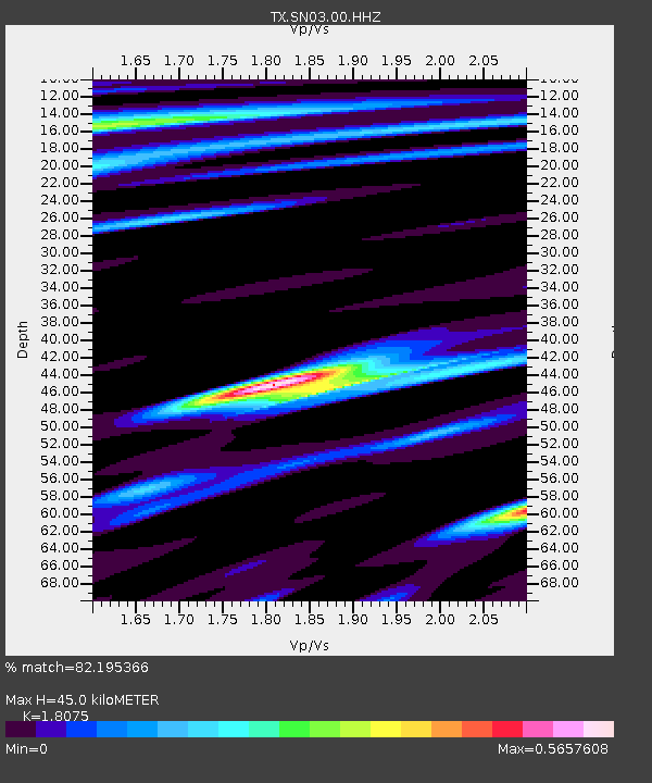
| Estimated Moho Depth: |
45.0 km |
| Estimated Crust Vp/Vs: |
1.81 |
| Assumed Crust Vp: |
6.426 km/s |
| Estimated Crust Vs: |
3.555 km/s |
| Estimated Crust Poisson's Ratio: |
0.28 |
|
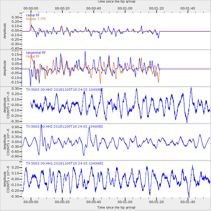
| Radial Match: |
82.195366 % |
| Radial Bump: |
400 |
| Transverse Match: |
57.276577 % |
| Transverse Bump: |
398 |
| SOD ConfigId: |
3131071 |
| Insert Time: |
2018-11-20 16:25:56.473 +0000 |
| GWidth: |
2.5 |
| Max Bumps: |
400 |
| Tol: |
0.001 |
|
Signal To Noise
| Channel | StoN | STA | LTA |
| TX:SN03:00:HHZ:20181106T16:24:03.104998Z | 2.543819 | 2.4252714E-7 | 9.533978E-8 |
| TX:SN03:00:HH1:20181106T16:24:03.104998Z | 0.5568481 | 6.7548775E-8 | 1.2130558E-7 |
| TX:SN03:00:HH2:20181106T16:24:03.104998Z | 1.8107774 | 1.2962167E-7 | 7.158344E-8 |
| Arrivals |
| Ps | 5.8 SECOND |
| PpPs | 19 SECOND |
| PsPs/PpSs | 25 SECOND |


