You are here: Home > Network List > UU - University of Utah Regional Network Stations List
> Station MOUT Mount Ogden, UT, USA > Earthquake Result Viewer
MOUT Mount Ogden, UT, USA - Earthquake Result Viewer
| Earthquake location: |
Tonga Islands Region |
| Earthquake latitude/longitude: |
-23.6/-175.9 |
| Earthquake time(UTC): |
2023/06/16 (167) 08:11:34 GMT |
| Earthquake Depth: |
22 km |
| Earthquake Magnitude: |
6.0 mww |
| Earthquake Catalog/Contributor: |
NEIC PDE/us |
|
| Network: |
UU University of Utah Regional Network |
| Station: |
MOUT Mount Ogden, UT, USA |
| Lat/Lon: |
41.20 N/111.88 W |
| Elevation: |
2748 m |
|
| Distance: |
87.6 deg |
| Az: |
42.756 deg |
| Baz: |
235.635 deg |
| Ray Param: |
0.043219272 |
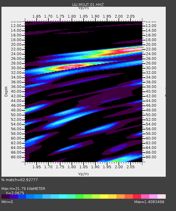
| Estimated Moho Depth: |
21.75 km |
| Estimated Crust Vp/Vs: |
2.07 |
| Assumed Crust Vp: |
6.155 km/s |
| Estimated Crust Vs: |
2.977 km/s |
| Estimated Crust Poisson's Ratio: |
0.35 |
|
| Radial Match: |
82.92777 % |
| Radial Bump: |
400 |
| Transverse Match: |
28.95398 % |
| Transverse Bump: |
400 |
| SOD ConfigId: |
30536071 |
| Insert Time: |
2023-06-30 08:39:35.969 +0000 |
| GWidth: |
2.5 |
| Max Bumps: |
400 |
| Tol: |
0.001 |
|

Signal To Noise
| Channel | StoN | STA | LTA |
| UU:MOUT:01:HHZ:20230616T08:23:49.249999Z | 5.95197 | 3.83225E-7 | 6.438624E-8 |
| UU:MOUT:01:HHN:20230616T08:23:49.249999Z | 2.2078586 | 2.6101623E-7 | 1.18221436E-7 |
| UU:MOUT:01:HHE:20230616T08:23:49.249999Z | 2.2505653 | 2.6343724E-7 | 1.1705381E-7 |
| Arrivals |
| Ps | 3.8 SECOND |
| PpPs | 11 SECOND |
| PsPs/PpSs | 14 SECOND |


