You are here: Home > Network List > TA - USArray Transportable Network (new EarthScope stations) Stations List
> Station T36A Boggs Farm, Caney, KS, USA > Earthquake Result Viewer
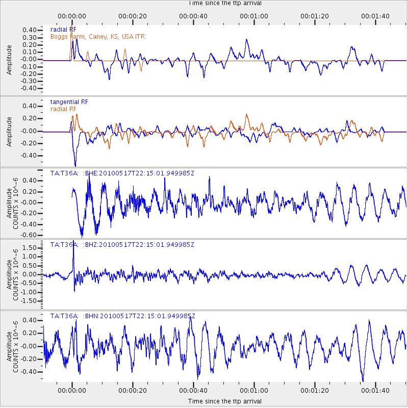
T36A Boggs Farm, Caney, KS, USA - Earthquake Result Viewer
*The percent match for this event was below the threshold and hence no stack was calculated.
| Earthquake location: |
Kuril Islands |
| Earthquake latitude/longitude: |
46.3/152.0 |
| Earthquake time(UTC): |
2010/05/17 (137) 22:03:47 GMT |
| Earthquake Depth: |
73 km |
| Earthquake Magnitude: |
5.7 MB, 5.3 MW |
| Earthquake Catalog/Contributor: |
WHDF/NEIC |
|
| Network: |
TA USArray Transportable Network (new EarthScope stations) |
| Station: |
T36A Boggs Farm, Caney, KS, USA |
| Lat/Lon: |
37.06 N/95.88 W |
| Elevation: |
243 m |
|
| Distance: |
77.1 deg |
| Az: |
49.499 deg |
| Baz: |
318.765 deg |
| Ray Param: |
$rayparam |
*The percent match for this event was below the threshold and hence was not used in the summary stack. |
|
| Radial Match: |
54.869156 % |
| Radial Bump: |
400 |
| Transverse Match: |
86.30529 % |
| Transverse Bump: |
400 |
| SOD ConfigId: |
314592 |
| Insert Time: |
2010-09-04 07:06:51.131 +0000 |
| GWidth: |
2.5 |
| Max Bumps: |
400 |
| Tol: |
0.001 |
|
Signal To Noise
| Channel | StoN | STA | LTA |
| TA:T36A: :BHZ:20100517T22:15:01.949985Z | 2.5088453 | 4.6615992E-7 | 1.8580656E-7 |
| TA:T36A: :BHN:20100517T22:15:01.949985Z | 1.372204 | 2.1511438E-7 | 1.567656E-7 |
| TA:T36A: :BHE:20100517T22:15:01.949985Z | 0.7029077 | 1.6313906E-7 | 2.3209174E-7 |
| Arrivals |
| Ps | |
| PpPs | |
| PsPs/PpSs | |


