You are here: Home > Network List > AV - Alaska Volcano Observatory Stations List
> Station AMKA Regional Station, Amchitka Island, Alaska > Earthquake Result Viewer
AMKA Regional Station, Amchitka Island, Alaska - Earthquake Result Viewer
| Earthquake location: |
Tonga Islands Region |
| Earthquake latitude/longitude: |
-23.8/-175.2 |
| Earthquake time(UTC): |
2023/06/16 (167) 19:10:52 GMT |
| Earthquake Depth: |
10 km |
| Earthquake Magnitude: |
6.5 Mi |
| Earthquake Catalog/Contributor: |
NEIC PDE/pt |
|
| Network: |
AV Alaska Volcano Observatory |
| Station: |
AMKA Regional Station, Amchitka Island, Alaska |
| Lat/Lon: |
51.38 N/179.30 E |
| Elevation: |
116 m |
|
| Distance: |
75.0 deg |
| Az: |
356.417 deg |
| Baz: |
174.759 deg |
| Ray Param: |
0.051969573 |
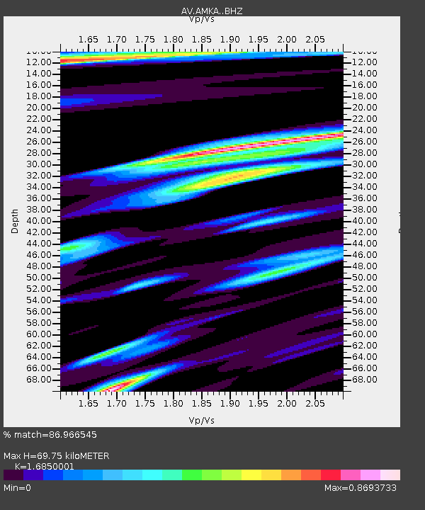
| Estimated Moho Depth: |
69.75 km |
| Estimated Crust Vp/Vs: |
1.69 |
| Assumed Crust Vp: |
6.183 km/s |
| Estimated Crust Vs: |
3.669 km/s |
| Estimated Crust Poisson's Ratio: |
0.23 |
|
| Radial Match: |
86.966545 % |
| Radial Bump: |
400 |
| Transverse Match: |
77.375374 % |
| Transverse Bump: |
398 |
| SOD ConfigId: |
30536071 |
| Insert Time: |
2023-06-30 19:17:48.286 +0000 |
| GWidth: |
2.5 |
| Max Bumps: |
400 |
| Tol: |
0.001 |
|
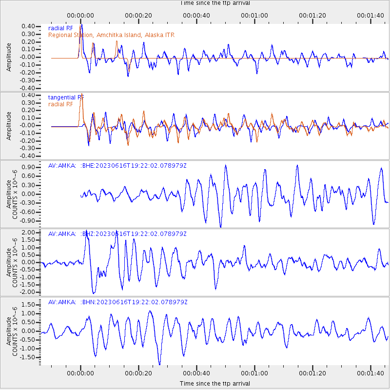
Signal To Noise
| Channel | StoN | STA | LTA |
| AV:AMKA: :BHZ:20230616T19:22:02.078979Z | 10.859109 | 1.226701E-6 | 1.1296516E-7 |
| AV:AMKA: :BHN:20230616T19:22:02.078979Z | 3.2157958 | 5.582135E-7 | 1.7358488E-7 |
| AV:AMKA: :BHE:20230616T19:22:02.078979Z | 1.2026943 | 1.4231082E-7 | 1.1832669E-7 |
| Arrivals |
| Ps | 8.0 SECOND |
| PpPs | 29 SECOND |
| PsPs/PpSs | 37 SECOND |


