You are here: Home > Network List > AV - Alaska Volcano Observatory Stations List
> Station ETKA Kagalaska Island, Regional Station, Alaska > Earthquake Result Viewer
ETKA Kagalaska Island, Regional Station, Alaska - Earthquake Result Viewer
| Earthquake location: |
Tonga Islands Region |
| Earthquake latitude/longitude: |
-23.8/-175.2 |
| Earthquake time(UTC): |
2023/06/16 (167) 19:10:52 GMT |
| Earthquake Depth: |
10 km |
| Earthquake Magnitude: |
6.5 Mi |
| Earthquake Catalog/Contributor: |
NEIC PDE/pt |
|
| Network: |
AV Alaska Volcano Observatory |
| Station: |
ETKA Kagalaska Island, Regional Station, Alaska |
| Lat/Lon: |
51.86 N/176.41 W |
| Elevation: |
290 m |
|
| Distance: |
75.3 deg |
| Az: |
359.208 deg |
| Baz: |
178.83 deg |
| Ray Param: |
0.051753156 |
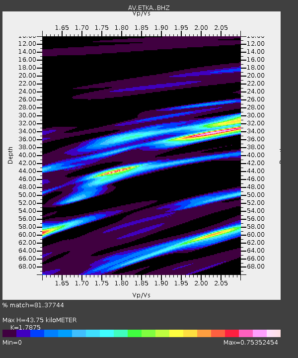
| Estimated Moho Depth: |
43.75 km |
| Estimated Crust Vp/Vs: |
1.79 |
| Assumed Crust Vp: |
5.88 km/s |
| Estimated Crust Vs: |
3.29 km/s |
| Estimated Crust Poisson's Ratio: |
0.27 |
|
| Radial Match: |
81.37744 % |
| Radial Bump: |
397 |
| Transverse Match: |
66.008575 % |
| Transverse Bump: |
400 |
| SOD ConfigId: |
30536071 |
| Insert Time: |
2023-06-30 19:18:23.918 +0000 |
| GWidth: |
2.5 |
| Max Bumps: |
400 |
| Tol: |
0.001 |
|

Signal To Noise
| Channel | StoN | STA | LTA |
| AV:ETKA: :BHZ:20230616T19:22:04.000Z | 7.8687224 | 2.4774372E-6 | 3.1484615E-7 |
| AV:ETKA: :BHN:20230616T19:22:04.000Z | 4.2758527 | 1.3957696E-6 | 3.264307E-7 |
| AV:ETKA: :BHE:20230616T19:22:04.000Z | 1.1754371 | 3.9601287E-7 | 3.369069E-7 |
| Arrivals |
| Ps | 6.0 SECOND |
| PpPs | 20 SECOND |
| PsPs/PpSs | 26 SECOND |


