You are here: Home > Network List > AV - Alaska Volcano Observatory Stations List
> Station GANO North, Gareloi Volcano, Alaska > Earthquake Result Viewer
GANO North, Gareloi Volcano, Alaska - Earthquake Result Viewer
| Earthquake location: |
Tonga Islands Region |
| Earthquake latitude/longitude: |
-23.8/-175.2 |
| Earthquake time(UTC): |
2023/06/16 (167) 19:10:52 GMT |
| Earthquake Depth: |
10 km |
| Earthquake Magnitude: |
6.5 Mi |
| Earthquake Catalog/Contributor: |
NEIC PDE/pt |
|
| Network: |
AV Alaska Volcano Observatory |
| Station: |
GANO North, Gareloi Volcano, Alaska |
| Lat/Lon: |
51.82 N/178.81 W |
| Elevation: |
451 m |
|
| Distance: |
75.3 deg |
| Az: |
357.669 deg |
| Baz: |
176.559 deg |
| Ray Param: |
0.051741596 |
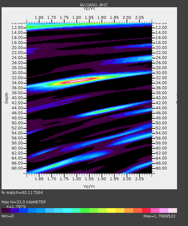
| Estimated Moho Depth: |
33.0 km |
| Estimated Crust Vp/Vs: |
1.80 |
| Assumed Crust Vp: |
6.048 km/s |
| Estimated Crust Vs: |
3.365 km/s |
| Estimated Crust Poisson's Ratio: |
0.28 |
|
| Radial Match: |
80.117584 % |
| Radial Bump: |
400 |
| Transverse Match: |
76.71951 % |
| Transverse Bump: |
400 |
| SOD ConfigId: |
30536071 |
| Insert Time: |
2023-06-30 19:18:29.975 +0000 |
| GWidth: |
2.5 |
| Max Bumps: |
400 |
| Tol: |
0.001 |
|

Signal To Noise
| Channel | StoN | STA | LTA |
| AV:GANO: :BHZ:20230616T19:22:04.099976Z | 11.927097 | 2.6494868E-6 | 2.2214012E-7 |
| AV:GANO: :BHN:20230616T19:22:04.099976Z | 1.9684339 | 1.1193538E-6 | 5.6865196E-7 |
| AV:GANO: :BHE:20230616T19:22:04.099976Z | 2.6110148 | 2.20038E-6 | 8.4272983E-7 |
| Arrivals |
| Ps | 4.5 SECOND |
| PpPs | 15 SECOND |
| PsPs/PpSs | 19 SECOND |


