You are here: Home > Network List > AV - Alaska Volcano Observatory Stations List
> Station KEL Katmai Kelez, Alaska > Earthquake Result Viewer
KEL Katmai Kelez, Alaska - Earthquake Result Viewer
| Earthquake location: |
Tonga Islands Region |
| Earthquake latitude/longitude: |
-23.8/-175.2 |
| Earthquake time(UTC): |
2023/06/16 (167) 19:10:52 GMT |
| Earthquake Depth: |
10 km |
| Earthquake Magnitude: |
6.5 Mi |
| Earthquake Catalog/Contributor: |
NEIC PDE/pt |
|
| Network: |
AV Alaska Volcano Observatory |
| Station: |
KEL Katmai Kelez, Alaska |
| Lat/Lon: |
58.44 N/155.74 W |
| Elevation: |
975 m |
|
| Distance: |
83.5 deg |
| Az: |
10.142 deg |
| Baz: |
197.861 deg |
| Ray Param: |
0.04615551 |
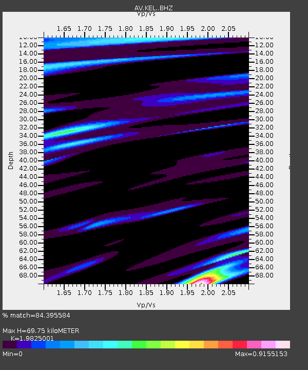
| Estimated Moho Depth: |
69.75 km |
| Estimated Crust Vp/Vs: |
1.98 |
| Assumed Crust Vp: |
6.438 km/s |
| Estimated Crust Vs: |
3.248 km/s |
| Estimated Crust Poisson's Ratio: |
0.33 |
|
| Radial Match: |
84.395584 % |
| Radial Bump: |
400 |
| Transverse Match: |
71.707794 % |
| Transverse Bump: |
400 |
| SOD ConfigId: |
30536071 |
| Insert Time: |
2023-06-30 19:19:02.892 +0000 |
| GWidth: |
2.5 |
| Max Bumps: |
400 |
| Tol: |
0.001 |
|

Signal To Noise
| Channel | StoN | STA | LTA |
| AV:KEL: :BHZ:20230616T19:22:48.359009Z | 3.4699016 | 1.5713855E-6 | 4.5286168E-7 |
| AV:KEL: :BHN:20230616T19:22:48.359009Z | 2.2722075 | 5.3362356E-7 | 2.3484809E-7 |
| AV:KEL: :BHE:20230616T19:22:48.359009Z | 0.9592937 | 2.6477633E-7 | 2.7601175E-7 |
| Arrivals |
| Ps | 11 SECOND |
| PpPs | 32 SECOND |
| PsPs/PpSs | 42 SECOND |


