You are here: Home > Network List > AV - Alaska Volcano Observatory Stations List
> Station SPCR Ckakachatna River, Mount Spurr, Alaska > Earthquake Result Viewer
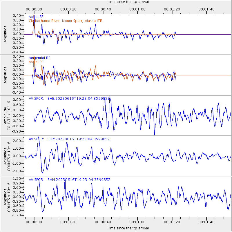
SPCR Ckakachatna River, Mount Spurr, Alaska - Earthquake Result Viewer
*The percent match for this event was below the threshold and hence no stack was calculated.
| Earthquake location: |
Tonga Islands Region |
| Earthquake latitude/longitude: |
-23.8/-175.2 |
| Earthquake time(UTC): |
2023/06/16 (167) 19:10:52 GMT |
| Earthquake Depth: |
10 km |
| Earthquake Magnitude: |
6.5 Mi |
| Earthquake Catalog/Contributor: |
NEIC PDE/pt |
|
| Network: |
AV Alaska Volcano Observatory |
| Station: |
SPCR Ckakachatna River, Mount Spurr, Alaska |
| Lat/Lon: |
61.20 N/152.21 W |
| Elevation: |
984 m |
|
| Distance: |
86.7 deg |
| Az: |
10.908 deg |
| Baz: |
200.977 deg |
| Ray Param: |
$rayparam |
*The percent match for this event was below the threshold and hence was not used in the summary stack. |
|
| Radial Match: |
73.18127 % |
| Radial Bump: |
400 |
| Transverse Match: |
53.257236 % |
| Transverse Bump: |
400 |
| SOD ConfigId: |
30536071 |
| Insert Time: |
2023-06-30 19:20:17.175 +0000 |
| GWidth: |
2.5 |
| Max Bumps: |
400 |
| Tol: |
0.001 |
|
Signal To Noise
| Channel | StoN | STA | LTA |
| AV:SPCR: :BHZ:20230616T19:23:04.359985Z | 5.447406 | 1.2361525E-6 | 2.2692498E-7 |
| AV:SPCR: :BHN:20230616T19:23:04.359985Z | 3.3844993 | 5.48401E-7 | 1.6203313E-7 |
| AV:SPCR: :BHE:20230616T19:23:04.359985Z | 1.2239219 | 2.5687248E-7 | 2.0987653E-7 |
| Arrivals |
| Ps | |
| PpPs | |
| PsPs/PpSs | |


