You are here: Home > Network List > US - United States National Seismic Network Stations List
> Station HDIL Hopedale, Illinois, USA > Earthquake Result Viewer
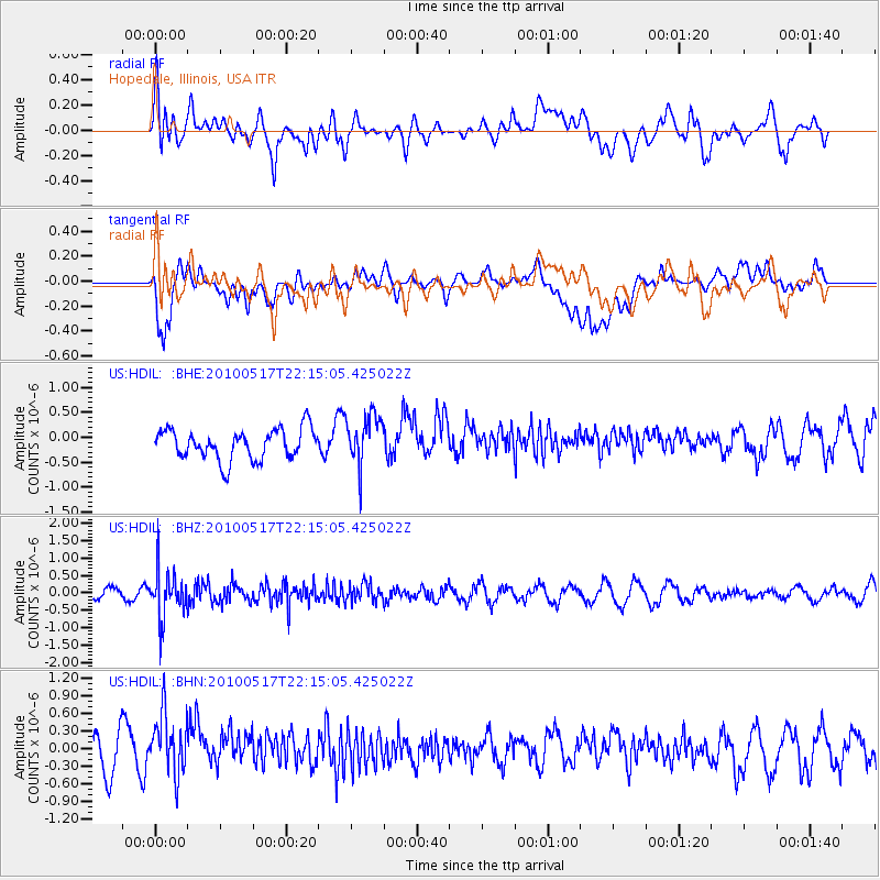
HDIL Hopedale, Illinois, USA - Earthquake Result Viewer
*The percent match for this event was below the threshold and hence no stack was calculated.
| Earthquake location: |
Kuril Islands |
| Earthquake latitude/longitude: |
46.3/152.0 |
| Earthquake time(UTC): |
2010/05/17 (137) 22:03:47 GMT |
| Earthquake Depth: |
73 km |
| Earthquake Magnitude: |
5.7 MB, 5.3 MW |
| Earthquake Catalog/Contributor: |
WHDF/NEIC |
|
| Network: |
US United States National Seismic Network |
| Station: |
HDIL Hopedale, Illinois, USA |
| Lat/Lon: |
40.56 N/89.29 W |
| Elevation: |
219 m |
|
| Distance: |
77.7 deg |
| Az: |
43.163 deg |
| Baz: |
321.495 deg |
| Ray Param: |
$rayparam |
*The percent match for this event was below the threshold and hence was not used in the summary stack. |
|
| Radial Match: |
61.01335 % |
| Radial Bump: |
400 |
| Transverse Match: |
60.826557 % |
| Transverse Bump: |
400 |
| SOD ConfigId: |
314592 |
| Insert Time: |
2010-09-04 07:09:26.196 +0000 |
| GWidth: |
2.5 |
| Max Bumps: |
400 |
| Tol: |
0.001 |
|
Signal To Noise
| Channel | StoN | STA | LTA |
| US:HDIL: :BHZ:20100517T22:15:05.425022Z | 3.6778262 | 6.799919E-7 | 1.8488961E-7 |
| US:HDIL: :BHN:20100517T22:15:05.425022Z | 1.4987473 | 5.2943136E-7 | 3.5324925E-7 |
| US:HDIL: :BHE:20100517T22:15:05.425022Z | 1.6547537 | 5.051054E-7 | 3.0524507E-7 |
| Arrivals |
| Ps | |
| PpPs | |
| PsPs/PpSs | |


