You are here: Home > Network List > CC - Cascade Chain Volcano Monitoring Stations List
> Station ARAT Mount Ararat > Earthquake Result Viewer
ARAT Mount Ararat - Earthquake Result Viewer
| Earthquake location: |
Tonga Islands Region |
| Earthquake latitude/longitude: |
-23.8/-175.2 |
| Earthquake time(UTC): |
2023/06/16 (167) 19:10:52 GMT |
| Earthquake Depth: |
10 km |
| Earthquake Magnitude: |
6.5 Mi |
| Earthquake Catalog/Contributor: |
NEIC PDE/pt |
|
| Network: |
CC Cascade Chain Volcano Monitoring |
| Station: |
ARAT Mount Ararat |
| Lat/Lon: |
46.79 N/121.85 W |
| Elevation: |
1822 m |
|
| Distance: |
85.1 deg |
| Az: |
33.576 deg |
| Baz: |
227.505 deg |
| Ray Param: |
0.044982113 |
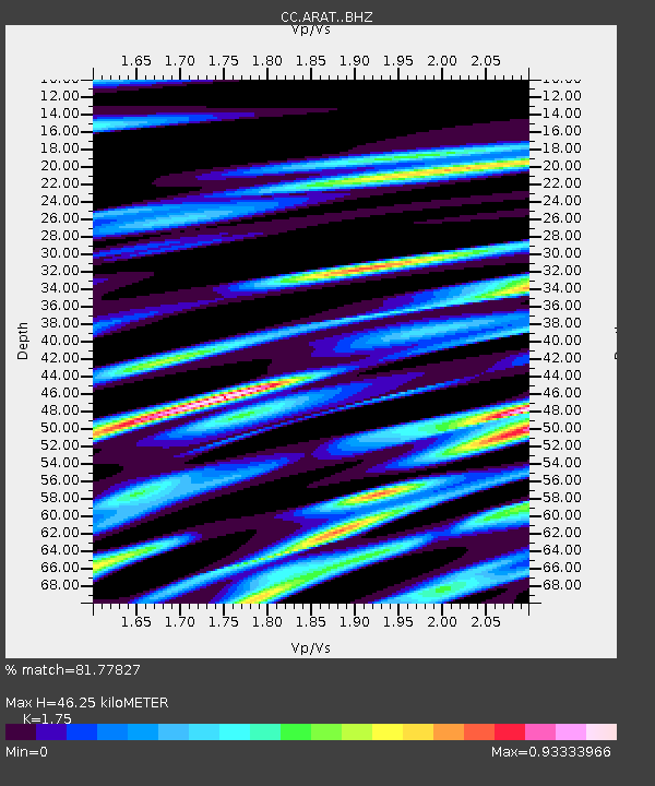
| Estimated Moho Depth: |
46.25 km |
| Estimated Crust Vp/Vs: |
1.75 |
| Assumed Crust Vp: |
6.597 km/s |
| Estimated Crust Vs: |
3.77 km/s |
| Estimated Crust Poisson's Ratio: |
0.26 |
|
| Radial Match: |
81.77827 % |
| Radial Bump: |
400 |
| Transverse Match: |
76.424225 % |
| Transverse Bump: |
400 |
| SOD ConfigId: |
30536071 |
| Insert Time: |
2023-06-30 19:22:21.718 +0000 |
| GWidth: |
2.5 |
| Max Bumps: |
400 |
| Tol: |
0.001 |
|

Signal To Noise
| Channel | StoN | STA | LTA |
| CC:ARAT: :BHZ:20230616T19:22:56.700012Z | 2.2038846 | 2.2315065E-7 | 1.0125333E-7 |
| CC:ARAT: :BHN:20230616T19:22:56.700012Z | 2.2740636 | 3.342256E-7 | 1.4697285E-7 |
| CC:ARAT: :BHE:20230616T19:22:56.700012Z | 1.1209017 | 1.3611727E-7 | 1.214355E-7 |
| Arrivals |
| Ps | 5.4 SECOND |
| PpPs | 19 SECOND |
| PsPs/PpSs | 24 SECOND |


