You are here: Home > Network List > UO - University of Oregon Regional Network Stations List
> Station MARQ Marquam, OR, USA > Earthquake Result Viewer
MARQ Marquam, OR, USA - Earthquake Result Viewer
| Earthquake location: |
Tonga Islands Region |
| Earthquake latitude/longitude: |
-23.8/-175.2 |
| Earthquake time(UTC): |
2023/06/16 (167) 19:10:52 GMT |
| Earthquake Depth: |
10 km |
| Earthquake Magnitude: |
6.5 Mi |
| Earthquake Catalog/Contributor: |
NEIC PDE/pt |
|
| Network: |
UO University of Oregon Regional Network |
| Station: |
MARQ Marquam, OR, USA |
| Lat/Lon: |
45.07 N/122.67 W |
| Elevation: |
159 m |
|
| Distance: |
83.6 deg |
| Az: |
34.46 deg |
| Baz: |
227.008 deg |
| Ray Param: |
0.04611096 |
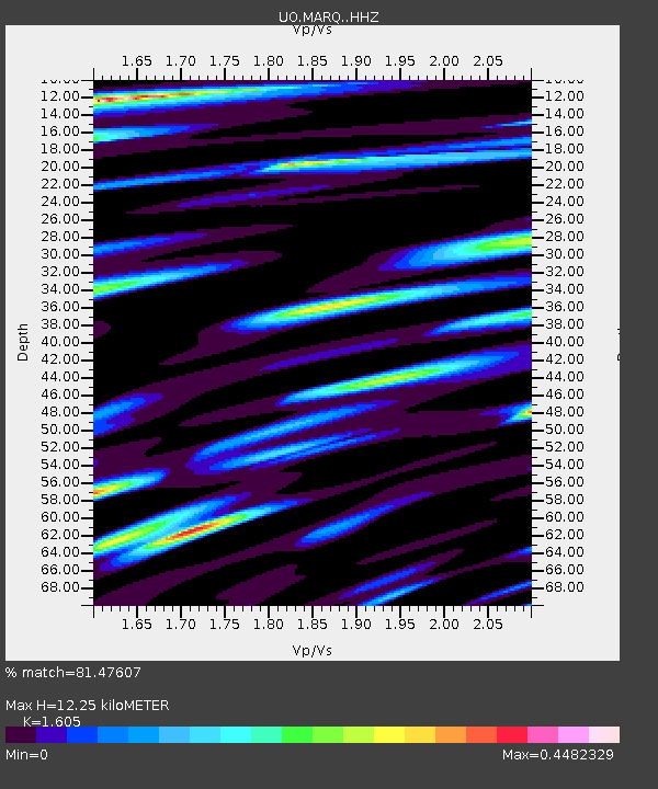
| Estimated Moho Depth: |
12.25 km |
| Estimated Crust Vp/Vs: |
1.61 |
| Assumed Crust Vp: |
6.566 km/s |
| Estimated Crust Vs: |
4.091 km/s |
| Estimated Crust Poisson's Ratio: |
0.18 |
|
| Radial Match: |
81.47607 % |
| Radial Bump: |
390 |
| Transverse Match: |
46.80377 % |
| Transverse Bump: |
400 |
| SOD ConfigId: |
30536071 |
| Insert Time: |
2023-06-30 19:36:12.589 +0000 |
| GWidth: |
2.5 |
| Max Bumps: |
400 |
| Tol: |
0.001 |
|

Signal To Noise
| Channel | StoN | STA | LTA |
| UO:MARQ: :HHZ:20230616T19:22:48.669983Z | 1.9571636 | 2.2681067E-7 | 1.1588744E-7 |
| UO:MARQ: :HHN:20230616T19:22:48.669983Z | 1.5110494 | 1.2731604E-7 | 8.4256705E-8 |
| UO:MARQ: :HHE:20230616T19:22:48.669983Z | 0.87557095 | 9.543834E-8 | 1.0900126E-7 |
| Arrivals |
| Ps | 1.2 SECOND |
| PpPs | 4.7 SECOND |
| PsPs/PpSs | 5.9 SECOND |


