You are here: Home > Network List > UW - Pacific Northwest Regional Seismic Network Stations List
> Station UMAT Pilot Rock, OR, USA > Earthquake Result Viewer
UMAT Pilot Rock, OR, USA - Earthquake Result Viewer
| Earthquake location: |
Tonga Islands Region |
| Earthquake latitude/longitude: |
-23.8/-175.2 |
| Earthquake time(UTC): |
2023/06/16 (167) 19:10:52 GMT |
| Earthquake Depth: |
10 km |
| Earthquake Magnitude: |
6.5 Mi |
| Earthquake Catalog/Contributor: |
NEIC PDE/pt |
|
| Network: |
UW Pacific Northwest Regional Seismic Network |
| Station: |
UMAT Pilot Rock, OR, USA |
| Lat/Lon: |
45.29 N/118.96 W |
| Elevation: |
1318 m |
|
| Distance: |
85.7 deg |
| Az: |
36.041 deg |
| Baz: |
229.779 deg |
| Ray Param: |
0.044604935 |
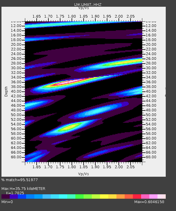
| Estimated Moho Depth: |
35.75 km |
| Estimated Crust Vp/Vs: |
1.78 |
| Assumed Crust Vp: |
6.571 km/s |
| Estimated Crust Vs: |
3.686 km/s |
| Estimated Crust Poisson's Ratio: |
0.27 |
|
| Radial Match: |
95.51977 % |
| Radial Bump: |
262 |
| Transverse Match: |
85.91011 % |
| Transverse Bump: |
391 |
| SOD ConfigId: |
30536071 |
| Insert Time: |
2023-06-30 19:39:32.477 +0000 |
| GWidth: |
2.5 |
| Max Bumps: |
400 |
| Tol: |
0.001 |
|
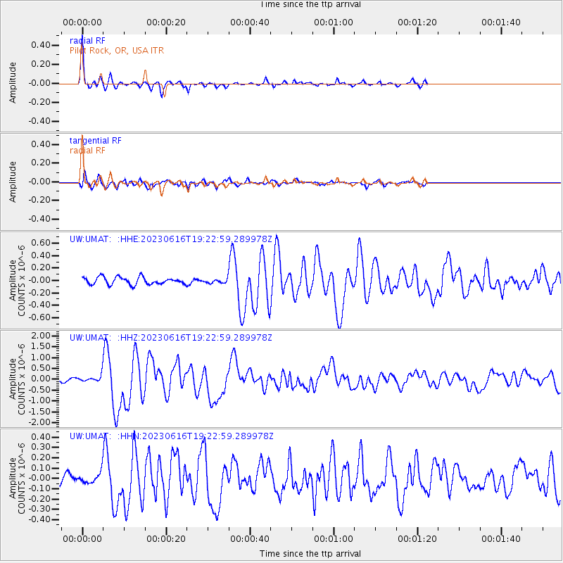
Signal To Noise
| Channel | StoN | STA | LTA |
| UW:UMAT: :HHZ:20230616T19:22:59.289978Z | 3.1154068 | 1.378299E-7 | 4.4241382E-8 |
| UW:UMAT: :HHN:20230616T19:22:59.289978Z | 0.6841356 | 4.9839926E-8 | 7.2850945E-8 |
| UW:UMAT: :HHE:20230616T19:22:59.289978Z | 0.5354767 | 3.104011E-8 | 5.796724E-8 |
| Arrivals |
| Ps | 4.4 SECOND |
| PpPs | 15 SECOND |
| PsPs/PpSs | 19 SECOND |


