You are here: Home > Network List > UW - Pacific Northwest Regional Seismic Network Stations List
> Station WOLL Wollman Farm, Schrag, WA, USA > Earthquake Result Viewer
WOLL Wollman Farm, Schrag, WA, USA - Earthquake Result Viewer

| Earthquake location: |
Tonga Islands Region |
| Earthquake latitude/longitude: |
-23.8/-175.2 |
| Earthquake time(UTC): |
2023/06/16 (167) 19:10:52 GMT |
| Earthquake Depth: |
10 km |
| Earthquake Magnitude: |
6.5 Mi |
| Earthquake Catalog/Contributor: |
NEIC PDE/pt |
|
| Network: |
UW Pacific Northwest Regional Seismic Network |
| Station: |
WOLL Wollman Farm, Schrag, WA, USA |
| Lat/Lon: |
47.06 N/118.92 W |
| Elevation: |
385 m |
|
| Distance: |
86.8 deg |
| Az: |
34.706 deg |
| Baz: |
229.72 deg |
| Ray Param: |
0.04377275 |
| Estimated Moho Depth: |
30.25 km |
| Estimated Crust Vp/Vs: |
1.73 |
| Assumed Crust Vp: |
6.419 km/s |
| Estimated Crust Vs: |
3.705 km/s |
| Estimated Crust Poisson's Ratio: |
0.25 |
|
| Radial Match: |
90.24876 % |
| Radial Bump: |
400 |
| Transverse Match: |
69.70873 % |
| Transverse Bump: |
363 |
| SOD ConfigId: |
30536071 |
| Insert Time: |
2023-06-30 19:39:40.697 +0000 |
| GWidth: |
2.5 |
| Max Bumps: |
400 |
| Tol: |
0.001 |
|
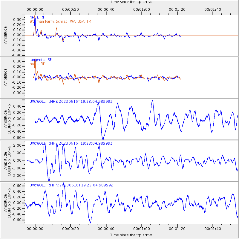
Signal To Noise
| Channel | StoN | STA | LTA |
| UW:WOLL: :HHZ:20230616T19:23:04.98999Z | 2.760664 | 3.0689898E-7 | 1.1116854E-7 |
| UW:WOLL: :HHN:20230616T19:23:04.98999Z | 0.9740978 | 6.703507E-8 | 6.88176E-8 |
| UW:WOLL: :HHE:20230616T19:23:04.98999Z | 2.1298425 | 1.364112E-7 | 6.4047555E-8 |
| Arrivals |
| Ps | 3.5 SECOND |
| PpPs | 13 SECOND |
| PsPs/PpSs | 16 SECOND |


