You are here: Home > Network List > US - United States National Seismic Network Stations List
> Station WMOK Wichita Mountains, Oklahoma, USA > Earthquake Result Viewer
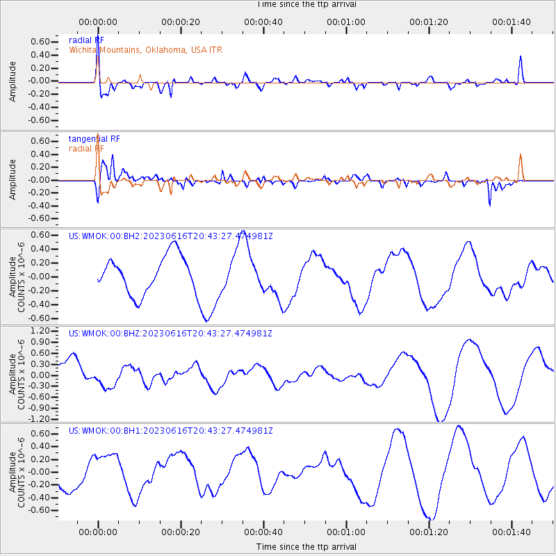
WMOK Wichita Mountains, Oklahoma, USA - Earthquake Result Viewer
*The percent match for this event was below the threshold and hence no stack was calculated.
| Earthquake location: |
Tonga Islands Region |
| Earthquake latitude/longitude: |
-23.5/-175.9 |
| Earthquake time(UTC): |
2023/06/16 (167) 20:30:44 GMT |
| Earthquake Depth: |
14 km |
| Earthquake Magnitude: |
5.5 Mww |
| Earthquake Catalog/Contributor: |
NEIC PDE/us |
|
| Network: |
US United States National Seismic Network |
| Station: |
WMOK Wichita Mountains, Oklahoma, USA |
| Lat/Lon: |
34.74 N/98.78 W |
| Elevation: |
486 m |
|
| Distance: |
93.3 deg |
| Az: |
53.532 deg |
| Baz: |
243.661 deg |
| Ray Param: |
$rayparam |
*The percent match for this event was below the threshold and hence was not used in the summary stack. |
|
| Radial Match: |
54.422764 % |
| Radial Bump: |
400 |
| Transverse Match: |
72.50198 % |
| Transverse Bump: |
400 |
| SOD ConfigId: |
30536071 |
| Insert Time: |
2023-06-30 20:49:21.093 +0000 |
| GWidth: |
2.5 |
| Max Bumps: |
400 |
| Tol: |
0.001 |
|
Signal To Noise
| Channel | StoN | STA | LTA |
| US:WMOK:00:BHZ:20230616T20:43:27.474981Z | 0.5194898 | 2.7068378E-7 | 5.2105696E-7 |
| US:WMOK:00:BH1:20230616T20:43:27.474981Z | 2.0149558 | 3.29489E-7 | 1.6352172E-7 |
| US:WMOK:00:BH2:20230616T20:43:27.474981Z | 1.2104324 | 3.2288133E-7 | 2.6674874E-7 |
| Arrivals |
| Ps | |
| PpPs | |
| PsPs/PpSs | |


