You are here: Home > Network List > NE - New England Seismic Network Stations List
> Station WES Weston Observatory, Weston, MA, USA > Earthquake Result Viewer
WES Weston Observatory, Weston, MA, USA - Earthquake Result Viewer
| Earthquake location: |
Jan Mayen Island Region |
| Earthquake latitude/longitude: |
71.6/-11.2 |
| Earthquake time(UTC): |
2018/11/09 (313) 01:49:40 GMT |
| Earthquake Depth: |
10 km |
| Earthquake Magnitude: |
6.8 Mww |
| Earthquake Catalog/Contributor: |
NEIC PDE/us |
|
| Network: |
NE New England Seismic Network |
| Station: |
WES Weston Observatory, Weston, MA, USA |
| Lat/Lon: |
42.38 N/71.32 W |
| Elevation: |
60 m |
|
| Distance: |
41.0 deg |
| Az: |
257.922 deg |
| Baz: |
24.749 deg |
| Ray Param: |
0.07403571 |
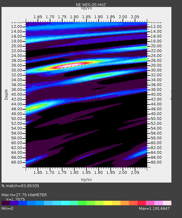
| Estimated Moho Depth: |
27.75 km |
| Estimated Crust Vp/Vs: |
1.79 |
| Assumed Crust Vp: |
6.419 km/s |
| Estimated Crust Vs: |
3.591 km/s |
| Estimated Crust Poisson's Ratio: |
0.27 |
|
| Radial Match: |
83.85305 % |
| Radial Bump: |
332 |
| Transverse Match: |
53.159977 % |
| Transverse Bump: |
400 |
| SOD ConfigId: |
3131071 |
| Insert Time: |
2018-11-23 01:59:59.660 +0000 |
| GWidth: |
2.5 |
| Max Bumps: |
400 |
| Tol: |
0.001 |
|

Signal To Noise
| Channel | StoN | STA | LTA |
| NE:WES:00:HHZ:20181109T01:56:52.814014Z | 2.1262228 | 8.724343E-7 | 4.1032123E-7 |
| NE:WES:00:HH1:20181109T01:56:52.814014Z | 2.3686023 | 5.810466E-7 | 2.45312E-7 |
| NE:WES:00:HH2:20181109T01:56:52.814014Z | 1.2432489 | 4.3924277E-7 | 3.5330234E-7 |
| Arrivals |
| Ps | 3.6 SECOND |
| PpPs | 11 SECOND |
| PsPs/PpSs | 15 SECOND |


