You are here: Home > Network List > AK - Alaska Regional Network Stations List
> Station J26L Joseph Creek, AK, USA > Earthquake Result Viewer
J26L Joseph Creek, AK, USA - Earthquake Result Viewer
| Earthquake location: |
Philippine Islands Region |
| Earthquake latitude/longitude: |
19.2/121.2 |
| Earthquake time(UTC): |
2023/06/17 (168) 10:15:21 GMT |
| Earthquake Depth: |
34 km |
| Earthquake Magnitude: |
5.5 mww |
| Earthquake Catalog/Contributor: |
NEIC PDE/us |
|
| Network: |
AK Alaska Regional Network |
| Station: |
J26L Joseph Creek, AK, USA |
| Lat/Lon: |
64.50 N/143.56 W |
| Elevation: |
1144 m |
|
| Distance: |
75.1 deg |
| Az: |
26.493 deg |
| Baz: |
283.111 deg |
| Ray Param: |
0.05185897 |
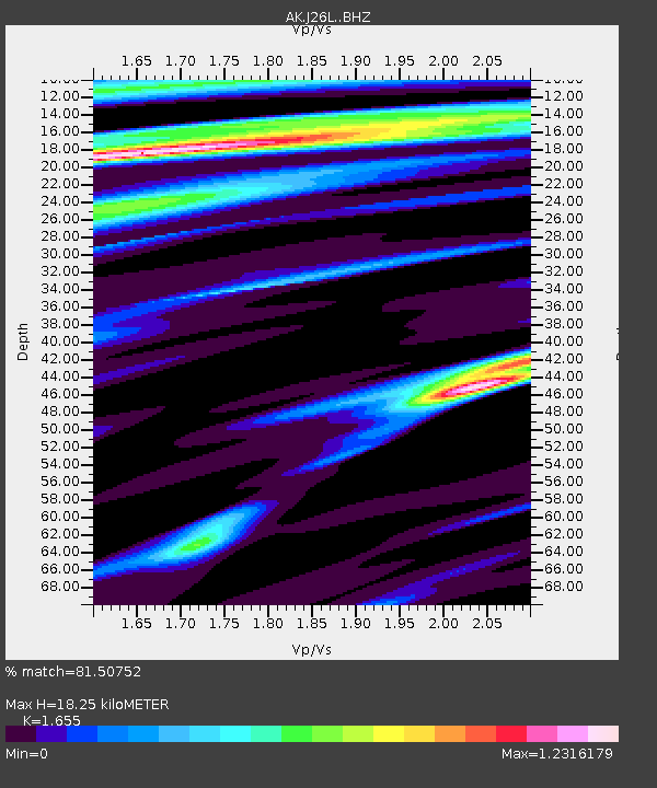
| Estimated Moho Depth: |
18.25 km |
| Estimated Crust Vp/Vs: |
1.65 |
| Assumed Crust Vp: |
6.566 km/s |
| Estimated Crust Vs: |
3.967 km/s |
| Estimated Crust Poisson's Ratio: |
0.21 |
|
| Radial Match: |
81.50752 % |
| Radial Bump: |
395 |
| Transverse Match: |
69.28569 % |
| Transverse Bump: |
400 |
| SOD ConfigId: |
30536071 |
| Insert Time: |
2023-07-01 10:18:13.791 +0000 |
| GWidth: |
2.5 |
| Max Bumps: |
400 |
| Tol: |
0.001 |
|

Signal To Noise
| Channel | StoN | STA | LTA |
| AK:J26L: :BHZ:20230617T10:26:28.660029Z | 1.7505616 | 3.099327E-7 | 1.7704758E-7 |
| AK:J26L: :BHN:20230617T10:26:28.660029Z | 1.402738 | 1.6578164E-7 | 1.1818434E-7 |
| AK:J26L: :BHE:20230617T10:26:28.660029Z | 0.48879895 | 7.5895E-8 | 1.5526834E-7 |
| Arrivals |
| Ps | 1.9 SECOND |
| PpPs | 7.1 SECOND |
| PsPs/PpSs | 9.0 SECOND |


